Subject: World
Period: 1775 (circa)
Publication:
Color: Black & White
Size:
20 x 11 inches
50.8 x 27.9 cm
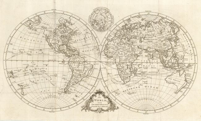
Double hemispheric copper engraved map showing the British colonies in North America. Virginia, the Carolinas, Georgia, and West Florida all extend westward to the Mississippi. Alaska has an indistinct coastline that extends nearly to Kamchatka with Mt. St. John near the end. The Northwest Passage is hinted at with dotted lines and rivers connecting lakes with the River of the West named. The routes of numerous explorers are traced across the oceans of the world. Very oddly, particularly so for a British map maker, the routes of Capt. Cook are dated 1760 and 1769. The 1760 date is completely erroneous as Cook surveyed the St. Lawrence Channel that year. In the cusp above the map is a smaller hemispheric map featuring the North Polar regions above 50°. With a rococo-style title cartouche.
References:
Condition: B
Folding as issued. Short binding side tear professionally closed and not affecting map image. A little surface soiling and tiny hole in Africa, else very good.