Subject: Central United States - Great Lakes
Period: 1781 (published)
Publication: Travels Through the Interior Parts Of North America…
Color: Black & White
Size:
13.5 x 10.5 inches
34.3 x 26.7 cm
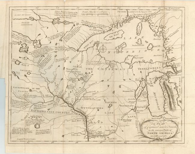
A terrific early map of the region of today's Wisconsin and Minnesota. Filled with details and notations such as "Traders go no farther than these falls" and "seldom travel this way except War Parties" and many more. The route of Carver's travels are clearly shown along the Mississippi, Fox, Minnesota and St. Pierre rivers. The map extends from Michigan, here labeled Chipeways and Ottowas Land, to above Lake Superior and west to beyond the Minnesota River. After the French and Indian War the peace settlement gave the British eastern Minnesota, opening the vast territory to their fur traders. Carver spent the winter of 1766-67 with the Sioux on the Minnesota River. He then joined Capt. James Tute's expedition as the mapmaker. Tute's plan was to cross the continent in quest of the Northwest Passage. The plan was not successful but their explorations led Carver to later publish an account of his travels. Carver is credited with traveling farther into the unknown West than any other English explorer before the Revolution. A very early and seldom seen map.
References: Rumsey #5915.
Condition: B
Folding, as issued. Good impression on thick hand laid paper. A little surface soiling and a couple fold intersection splits, closed on verso with archival tape. More soiling at some fold edges.