Subject: United States
Period: 1850 (published)
Publication: Mitchell's New Universal Atlas
Color: Hand Color
Size:
26 x 15.7 inches
66 x 39.9 cm
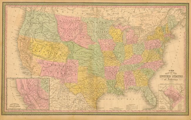
This great map was drawn by J.H. Young. The full original hand color graphically illustrates the large western territories of Oregon, Utah, New Mexico, Missouri, Minnesota, and Indian Territory and the pre-Gadsden purchase border with Mexico. Features some of the best early western territorial borders. A huge Oregon Territory extends east to join Missouri or Northwest Territory at the Continental Divide, which in turn joins a large Minnesota Territory. Indian Territory is a huge region stretching between Utah Territory to the west, Northwest Territory to the north, and to the south is Texas and New Mexico. The large New Mexico Territory includes all of today's Arizona and parts of Colorado and Nevada. This is the later 1850 edition that changes the name to Utah from Dessert. The entire Great Basin is here called the Fremont Basin. Early inset shows the Gold Region of California, and another the District of Columbia. Filled with Indian Tribes, forts, wagon roads, explorers routes, and much more.
References: Wheat (TMW) #685.
Condition: B
Original hand coloring on a sheet with original margins. Two light spots at bottom in Texas, a little soiling mostly in blank oceans, and clean 3" split at centerfold, closed on verso, else very good.