Subject: Asia - Eastern
Period: 1599 (published)
Publication: Caert-Thresoor
Color: Hand Color
Size:
4.8 x 3.7 inches
12.2 x 9.4 cm
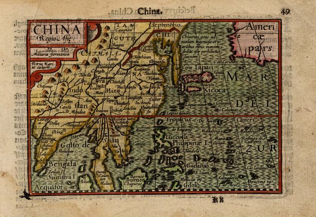
This charming miniature map shows China in the broader context of East Asia, extending to include India and the Malaysian peninsula as far south as Malacca. Its nomenclature and coastal profile appears to be copied from Plancius's 1594 map. The map extends into the Pacific to include Japan, the Philippines, and many Pacific Islands. There is a wide straight between Asia and Americae Pars. Korea is shown as an elongated peninsula. In China, the capital has two names, Xuntien and Quinzai, and the first Catholic church in mainland China is noted. The Great Wall extends past Korea. The sea is strongly engraved in a moiré pattern. Engraved by Petrus Kaerius with his signature in the strapwork title cartouche. Published in Cornelis Claesz's 1599 edition of Caert-Thresoor. Dutch text on verso.
References: Caboara #8.1.
Condition: A
Faint damp stains and light surface soil in blank margins.