Subject: Florida & Bahamas
Period: 1740 (circa)
Publication:
Color: Black & White
Size:
40 x 23.3 inches
101.6 x 59.2 cm
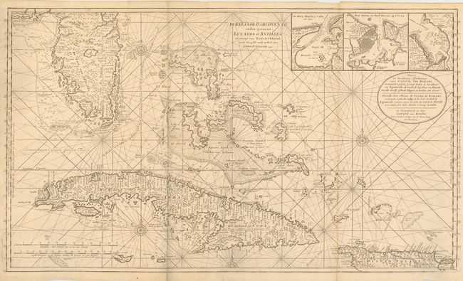
This superb, large-scale nautical chart is a landmark in the mapping of the Florida peninsula, Bahamas and Cuba. Southern Florida is shown in tremendous detail and includes dozens of place names, islands and soundings with an excellent depiction of the Keys. The fine detail extends throughout the Bahamas and Cuba and includes three inset plans of Havana, Hondo and Mantanacas Bays. Van Keulen based much of his map on English observations and includes two designations of latitude (English and Dutch) which vary by 30 minutes.
Gerard Van Keulen was the son of Johannes Van Keulen, patriarch of perhaps the most prolific of all Dutch map making families. The family firm commenced in 1680, but it was Gerard who brought it to its full glory in the 18th century. A talented engraver and mathematician, and later Hydrographer to the East India Company, Gerard became the mainspring of the business, issuing many important charts and books on all aspects of geography, navigation, etc. Until the opening of the Dutch Hydrographic Office in the 19th century, the Van Keulen firm issued what were regarded as the official Dutch sea charts.
References:
Condition: A
Old paper repair on a lower fold, else fine.