Subject: Panama
Period: 1907 (dated)
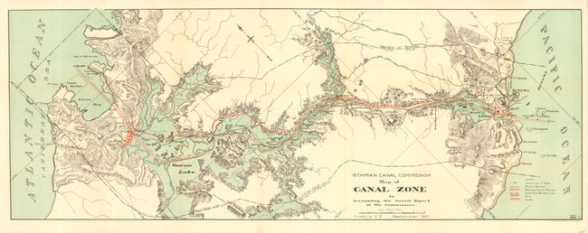
Publication: Isthmian Canal Commission
Color: Printed Color
Size:
32.2 x 12 inches
81.8 x 30.5 cm
A colorful and detailed map that delineates the course of the proposed canal, eventually opened in 1914. The map shows topography, the canal route, and railroads along the Panama Canal Zone. The legend locates the Centre Line of Canal, Panama Railroad, Relocated Panama Railroad, Canal Zone Boundary Line, Dams, and Locks through line, color, and iconography. Congress authorized construction of a 'lock' canal in June of 1906. The United States had previously gained use of a ten mile wide "Canal Zone" in a series of negotiations and treaties, as well as purchasing the property of the French Canal Company. Drawn in September, 1907 in Culebra, Canal Zone. Published by The Norris Petters Co., Washington, D.C. A scarce issue in fine condition.
References:
Condition: A+
Fine color and impression. Issued folding, now backed with archival tissue. Very light hint of toning at one fold.