Subject: Colonial Mid-Atlantic
Period: 1776 (dated)
Publication:
Color: Hand Color
Size:
26 x 19 inches
66 x 48.3 cm
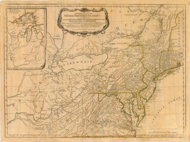
This is a later derivative of the seminal Lewis Evans map of the Middle British Colonies, which was one of the landmarks of American cartography. It has been updated to illustrate the Seat of War at the outbreak of the American Revolution from Governor Pownall's map of the same year. The map covers the region from Montreal and the lower end of Lake Huron to the North Carolina border, and from the Falls of the Ohio to Narragansett Bay, with an inset Sketch of the Upper Parts of Canada (Illinois Country). This map was an invaluable resource during the war and is filled with incredibly detailed information including provincial boundaries, courthouses, roads, trails, Indian villages and territories, forts, swamps, mines, portages, and distances between towns. Sayer and Bennett's imprint and the date, 15th Oct. 1776, just above the distance scale.
References: McCorkle #776.10; Sellers & Van Ee #714; Steven & Tree #30-f.
Condition: A
Light, slightly uneven toning with weak impression at corners, still overall very good. Small hole professionally infilled in an unengraved area of Virginia and a 'V' shaped tear in left margin, barely touching neatline.