Catalog Archive
Auction 109, Lot 520

"Gray's New Map of the Countries Surrounding The Black Sea - Comprising Turkey in Europe, and Part of Turkey in Asia, Greece (Hellas) Southern Russia etc.", Gray, Ormando Willis & Son

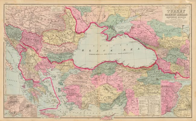
Subject: Black Sea and Balkans

Period: 1881 (published)

Publication: The National Atlas

Color: Hand Color

Size:
26.8 x 16.3 inches
68.1 x 41.4 cm
Download High Resolution Image
(or just click on image to launch the Zoom viewer)

A lovely double-page map that details the countries surrounding the Black Sea. Names and locates Croatia, Hertzegovinia, Bosnia, Servia, Scutari, Yanina, Monastir, Salonika, Roumania, Moldavia, Bulgaria, Eastern Roumelia, Bessarabia, Padolia, Kherson, Ekaterionoslav, Taurida and the Crimea, Country of the Cossacks of the Don, Kuban, Stavropol, Kutais, Angora, Khodavendikyar, and more. Good detail throughout Greece. Insets show the Environs of Athens and Piraeus, and The Bosphorus or Strait of Constantinople. Table gives the Etymological Explanation of Various Prefixes, Terminations and Formative Syllables. A most handsome chart with fine color that is dated 1879. Single-page maps of Russia and France on verso.

References:

Condition: A

Fine, dark impression with bright original hand coloring. Hint of toning along centerfold.

Estimate: $75 - $85

Sold for: $50

Closed on 12/1/2004

Archived