Subject: Texas and Oklahoma
Period: 1881 (published)
Publication: The National Atlas
Color: Hand Color
Size:
26.3 x 16 inches
66.8 x 40.6 cm
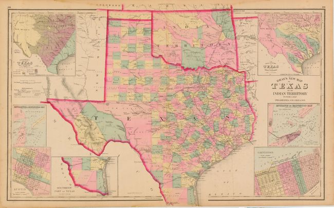
Terrific double-page map filled with detail. The state's rapid growth is evident from newly formed counties in the former huge panhandle section of Young Territory. Several railroads abruptly end between cities as the map indicates the exact progress to date. Details include numerous named railroads, cities, towns, watershed, forts, springs, and much more. Seven large insets include city plans for Austin and Galveston, the Entrance to Galveston Bay, and the River Systems. In Indian Territory the Public Lands are limited to the western panhandle. Locates and names the Indian lands of the Kiowa, Comanche, Apache, Chickasaw, Choctaw, Creek, Cherokee, Cheyenne, Osage, and Arrapahoe Tribes. Copyright date 1876, but published in 1881. A most handsome and desirable map of the region.
References:
Condition: B
Beautiful impression and coloring. Occasional light scattered foxing, else very good.