Subject: United States - Central
Period: 1860 (circa)
Publication: American State Papers, Military Affairs, Vol. VL
Color: Hand Color
Size:
17.5 x 10 inches
44.5 x 25.4 cm
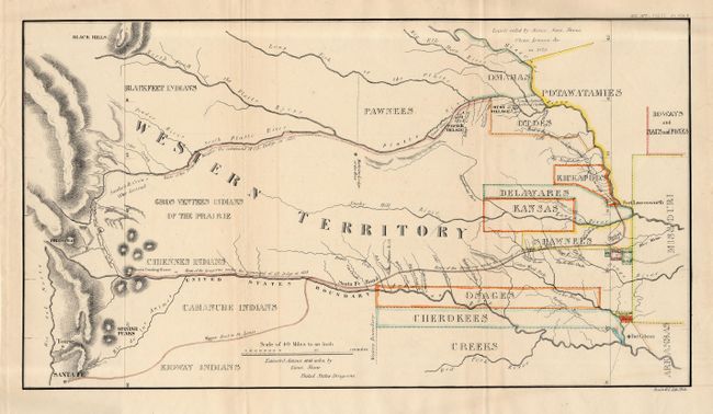
Map detailing the 1835 expedition of Dragoons under the command of Colonel Henry P. Dodge. The map, attributed to Lt. Steen, extends from Pike's Peak, Touse (Taos) and Santa Fe in the west and east to Fort Leavenworth. It locates rivers, creeks, mountains, Indian Reservations, Indian villages, Indian lands, military posts, the Santa Fe Trail, etc. The map was originally published in 1836 as part of HR Doc. 181, 24th Cong., 1st Session. A landmark map for illustrating land holdings of the Western Indians.
References: cf: Claussen & Friis #128; Wagner-Camp #63-2; Wheat [TMW] #421.
Condition: A
Issued folding, now backed with archival tissue. One small, light line of offsetting, still very good.