Subject: Western Hemisphere
Period: 1684 (dated)
Publication: Carte de geographie les plus nouvelles…
Color: Hand Color
Size:
15.4 x 14.4 inches
39.1 x 36.6 cm
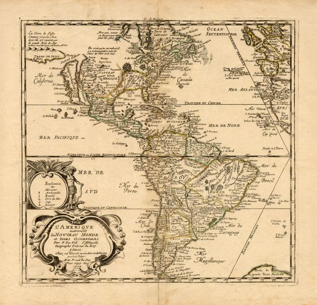
An uncommon map of the Americas based largely on the cartography of Nicolas Sanson, Duval's uncle. In North America the Great Lakes are shown open-ended in the west and California is depicted as an Island. Above California is the Destroit d' Anien and the large Terre de Iesso, or land of Jesso, that was the result of confusing reports by De Vries on his expedition in the waters north of Japan. Several colonial settlements appear on the eastern seaboard including Iamestoun, Christina, London al: Boston, N. Amsterdam al: Manhate. In South America the mythical Parime Lake is no longer in evidence and there is good detail, particularly of the missions. The map includes the western coasts of Europe and Africa, and a landmass appears at the bottom right labeled Partie de la grande Terre Australe. In the South Pacific are large title and key cartouches decorated with an Indian and crocodile. The map was originally engraved in 1655 and appeared in several states until Duval's death in1683. His widow Marie Desmaretz continued the business and issued this state with her imprint (sa Veuve) added to the cartouche.
References: Burden #311, state 9; McLaughlin #15, state 8.
Condition: B
Light toning, more so along centerfold. Fold separations into map at bottom and in top margin, closed with archival tape. Color is slightly faded.