Subject: United States - Midwest
Period: 1836 (published)
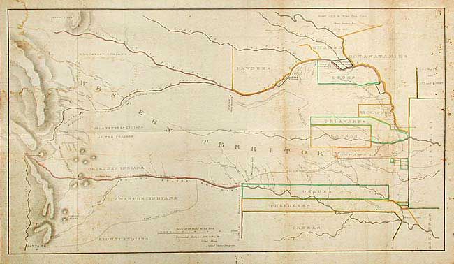
Publication: Journal of the Expedition…under the Command of Colonel Henry P. Dodge…
Color: Hand Color
Size:
35 x 19.5 inches
88.9 x 49.5 cm
A superb lithographed map covering the region of present day Kansas, Nebraska, and Colorado. The various Indian Districts are delineated and colored in outline with the notation "Lands Ceded by Sioux, Sacs, Foxes, Otoes, Ioways, &c. in 1825." The route of the Dragoons is shown starting at Ft. Levenworth and following the Santa Fe Road and then the Arkansas River (also marked as the United States Boundary) to just before Pike's Peak, then moving north through the Snake & Crow's War Ground to the return trip along the Platte River. Bent's Fort appears for the first time on this map and it is an early appearance of Pike's Peak. This is the original issue, not to be confused with the smaller issue from the American State Papers.
References: Claussen & Friis #128; Wagner-Camp #63-2; Wheat [TMW] #421.
Condition: B
Folds as issued. Scattered foxing and a small hole at a fold intersection.