Catalog Archive
Auction 104, Lot 514

"Tabula Geographica, in Qua Omnes Regiones, Urbes, Oppida, et Loca Describuntur, quorum mentio sit in Actis et Epistolis Apostolorum, et Apaocalypsi…", Plancius/Cloppenburg

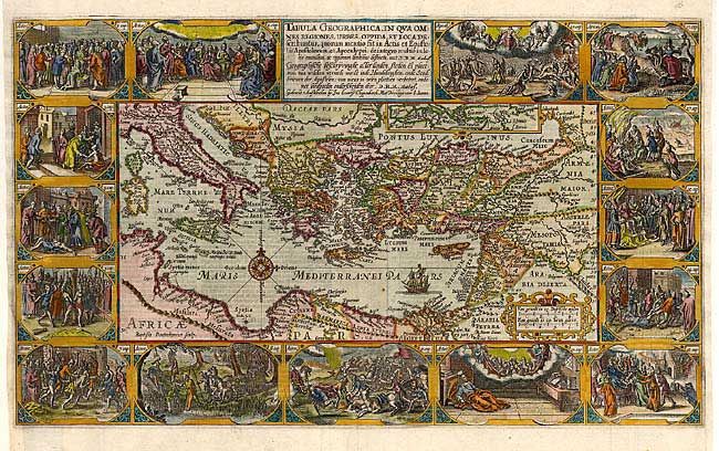
Subject: Eastern Mediterranean & Middle East

Period: 1604 (circa)

Publication:

Color: Hand Color

Size:
19.2 x 11.5 inches
48.8 x 29.2 cm
Download High Resolution Image
(or just click on image to launch the Zoom viewer)

Superb graphic map of the eastern Mediterranean, from Rome to Babylon, depicting the spread of Christianity as reported in the Acts of the Apostles. This is the final map of the standard set of five maps normally found in Dutch Bibles. The map is surrounded by fifteen Biblical vignettes including the apostles receiving heavenly inspiration and the apocalypse. The map includes a small inset of the whole Mediterranean region and is further decorated with a compass rose, sailing ship and strapwork distance scale. This is the second state with Plancius' name replaced by D.R.M. Mathes.

References: Poortman & Augusteijn #82.

Condition: A

Fine impression and later color. Bottom left margin professionally replaced with extremely skilled facsimile of a small part of the outside border. A couple of insignificant rust spots in map.

Estimate: $1,500 - $2,000

Sold for: $1,000

Closed on 9/10/2003

Archived