Subject: Minnesota
Period: 1874 (published)
Publication: Illustrated Historical Atlas of the State of Minnesota
Color: Printed Color
Size:
29.5 x 15.4 inches
74.9 x 39.1 cm
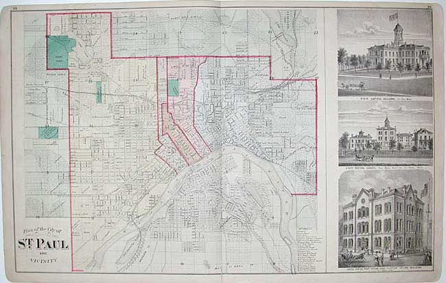
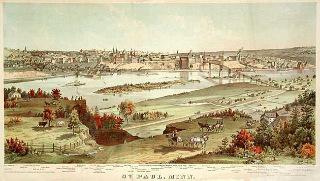
A fine set of city plan (19.5 x 16.4") and superb panorama of the city (29.5 X 15.4") by George Ellsbury and Vernon Green. The detailed city plan highlights 22 important buildings and is flanked by views of the Capitol Building, State Reform School and the U.S. Post Office and Custom House Building. The panorama with the Mississippi River in the foreground and the names of the prominent buildings below, is one of three large chromolithograph views from this remarkable atlas. This massive work was prepared by A.T. Andreas and sold by subscription to prominent landowners throughout the state. He chose Minnesota because the state was young, the population had money, and the eastern mapmakers had not yet worked the area. He brought together the production facilities in Chicago, canvassers to sell subscriptions, surveyors to create plat maps, writers to produce the written materials, and artists to draw illustrations of cities, farms and portraits. The result was a comprehensive and intimate portrait of the state and is a wealth of historical information today. The verso of the plan is filled with several illustrations of the businesses in St. Paul.
References: Phillips (A) #2007; Ristow, pp. 433-439.
Condition: B
Plan with 1" fold separation at bottom closed with archival tape. View with some paper replaced in bottom blank margin and a couple of professional repairs on folds.