Subject: Southwestern United States
Period: 1858 (dated)
Publication: Report upon the Colorado River of the West…
Color: Black & White
Size:
34.7 x 14.6 inches
88.1 x 37.1 cm
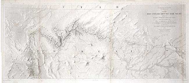
This map is from a series of four and represents one of the most important exploring efforts of the American Southwest. The series shows the lower Colorado River in four panels; this map details the region around the Grand Canyon and Little Colorado River. It shows the river from about Needles (Whipple's Crossing and Mojave Canyon) north through Black Canyon, to the Little Colorado and then north to beyond the survey's limit as the riverbed fades to nothing. In his book "Mapping of the Trans-Mississippi West" Carl Wheat devotes several pages to these maps. Finely and fully engraved the map locates Fort Defiance, Campbell's Pass, Zuni, Moquis (Hopi) Pueblos, San Francisco Springs (Flagstaff), Las Vegas, the Mormon Road, numerous Indian tribes, and much more. Several important exploration routes & trails are shown including The Old Spanish Trail, Whipple's trail 1854-4 and Beale's trail. Many notations throughout.
References: Wheat [TMW] #947.
Condition: B
Issued folding, now pressed and tissue backed. Light toning along some folds and two light areas of foxing, else very good.