Catalog Archive
Auction 103, Lot 141

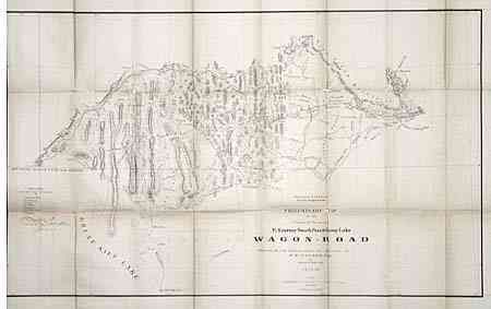
"Dept of the Interior Pacific Wagon Roads. Preliminary Map of the Central Division Ft. Kearney South Pass & Honey Lake Wagon-Road…", U.S. Government

Subject: Western United States

Period: 1857-58 (dated)

Publication: Campbell's Wagon Roads…A Report Upon the Several Roads Constructed

Color: Black & White

Size:
34 x 20.5 inches
86.4 x 52.1 cm
Download High Resolution Image
(or just click on image to launch the Zoom viewer)

Very detailed with topography shown via hachure. Centered roughly on Bear Lake, the map extends from City of the Rocks and American Falls in the West to Fort Aspen and Gilbert's Trading Post at the east. Salt Lake City is located at the extreme bottom. Locates numerous place names, mountain passes, etc. Names forts: Hall, Piney, Thompson and Aspen.

References: Wheat (TMW) #1004.

Condition: C

Toned, with splits along one fold due to brittle paper. Will benefit from conservation and tissue backing.

Estimate: $80 - $100

Sold for: $110

Closed on 6/11/2003

Archived