Subject: History
Period: 1846 (published)
Publication:
Color: Black & White
Size:
5 x 8 inches
12.7 x 20.3 cm
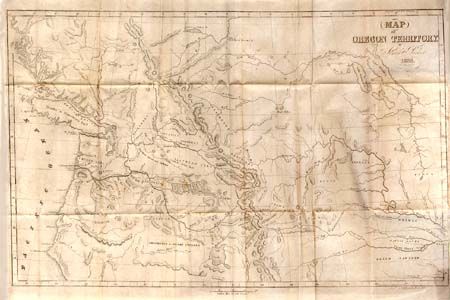
This tour covered an extensive area and provided important information on several subjects: American Fur Company; Oregon Territory; Hudson Bay Company; Presbyterian missionary; Nez Perce, Calapooa, Chenook, Klicatat, La Dalles, and Paloose Indians; overland journals; surgery on Jim Bridger; Sandwich Islands and much more. The folding map titled Map of Oregon Territory…, 1838 and the wood engraving of the Basaltic Formations on the Columbia River are both present. The map (22.5"x14") is scarce and according to Wheat is the earliest accurate map of the Pacific Northwest. Original brown embossed cloth with gilt title on spine. Fifth edition, 422pp+6 pages of ads. An important book and map, well deserving of conservation and rebinding.
References: Howes P89; Sabin 58729; Wagner-Camp 70; Wheat [TMW] 438.
Condition: B
Map is overall very good with a tiny bit of foxing and two small binding tears, closed with archival tape. Covers worn, couple of signatures loose. Contents with scattered foxing.