Subject: South Carolina
Period: 1865 (dated)
Publication:
Color: Printed Color
Size:
24.8 x 21.7 inches
63 x 55.1 cm
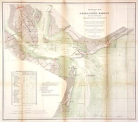
This map was produced by direction of Rear Admiral J.A. Dahlgren U.S.N. commanding South Atlantic Blockading Squadron, by C.O. Boutelle Asst. U.S. Coast Survey. The map shows the surveys of the shore line, channels, and fortifications with the location of Union and Rebel Batteries shown in color. Details positions of obstructions (shipwrecks etc.) and torpedoes including the Housatonic, etc. Tables lower left notes the armaments of Rebel forts and provide keys to items shown on the map. Charleston is shown as a detailed street grid. Possibly the best chart of Charleston Harbor of the Civil War era. Extends to include Forts Shaw, Marshall, Sumter, Wagner and Johnson, plus many batteries.
References:
Condition: B
Backed with archival tissue with some splitting along one fold. Toned along some folds, else very good.