Subject: United States
Period: 1857 (dated)
Publication:
Color: Hand Color
Size:
30 x 13.5 inches
76.2 x 34.3 cm
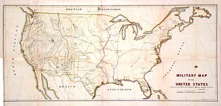
Wheat calls this map "illuminating" as it clearly shows how the military establishment in the Far West had grown following the war with Mexico. A dark line shows the "Extreme line of outposts in 1845" and none are west of the 100th meridian. The western area is divided into military districts and the numerous forts for protection of the frontier are shown therein. Several recent exploration routes are traced along with the locations of the various military forts, arsenals and barracks.
References: Wheat [TMW] #929.
Condition: B
Binder's trim to neatline at left. Light toning along folds with some repairs on verso.