Subject: North Sea
Period: 1636-1662 (circa)
Publication:
Color: Black & White
Size:
21.7 x 16.5 inches
55.1 x 41.9 cm
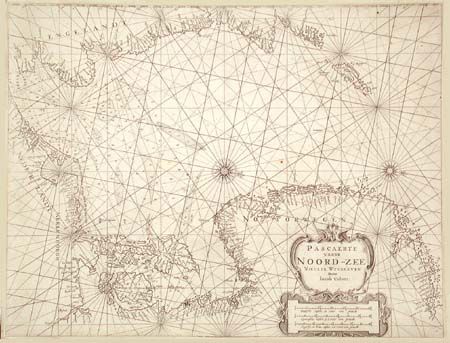
A strong and handsome copper engraved chart, most likely from Colom's Vyerighe Colom atlas. Features fine detail along coastlines and seas. Shows the region from London northward through Scotland and up to the Shetland Islands, all of the European coast from Belgium through Holland, and Denmark and up the coast of Norway to above Sogna-fjorden. Filled with soundings, shoals, and a beautiful array of rhumb lines. Two very fancy compass roses indicate north to the right and a large decorative title cartouche completes this lovely and rarely seen sea chart.
References: Koeman J. Col 9 (1).
Condition: A
Crisp, fine impression on thick chart paper, close trimmed. Two small rust spots, still very good.