Subject: Texas
Period: 1902 (published)
Publication: US Geological Survey Bulletin 194
Color: Black & White
Size:
40 x 26.3 inches
101.6 x 66.8 cm
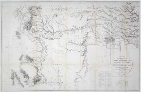
By J.H. Clark, U.S. Commissioner, drawn by J.E. Weyss, circa 1860. The map features the survey lines between Texas and New Mexico with good topographical detail. Locates forts, Raton Pass, the Santa Fe and Albuquerque trails, numerous explorer's routes, and Indian trails. The map is an interesting historical curiosity because it was not published when the survey was finished due to the outbreak of the Civil War. In 1902 it was belatedly included in a Geological Survey Bulletin by Marcus Baker. Large and extremely detailed chart. A table lists numerous points that can be easily found to aid the traveler. A most unusual Texas cartographic piece.
References: Wheat [TMW] #1022.
Condition: A
Issued folding, now backed with archival tissue. A little toning along some folds, but still very good for a map for this size.