Subject: World
Period: 1660 (circa)
Publication:
Color: Hand Color
Size:
19 x 12.4 inches
48.3 x 31.5 cm
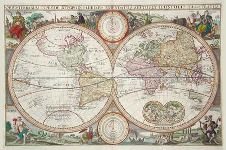
This map is a direct derivative of Nicolas Visscher's first world map designed for inclusion in Dutch Bibles. It has been re-engraved, is nominally larger, and this example is from a German Bible. Identical engravings including allegorical representations of the continents as well as native inhabitants and wildlife surround the double hemisphere world map. Two celestial spheres are displayed in the Eastern Hemisphere. In the lower part of the Western Hemisphere is text describing the discovery of America and recent voyages of discovery. Two diagrams depicting the Ptolemaic and Copernican theories of the solar system are tucked between the hemispheres. The northwest coast of North America is exaggerated and shows California correctly as a peninsula. Parts of Australia and Van Diemen's Land are shown but the north coast of Australia is not depicted. It also includes the western coastline of New Zealand. German text on verso. Shirley notes several derivatives in his Corrigenda and Addenda (2001 revised edition of The Mapping of the World). This most closely matches #414A, although there is no additional outer scroll border.
References: Shirley #414.
Condition: A
Wide margins. Expert repair of bottom fold in blank margin. Minor foxing in margins.