Catalog Archive
Auction 101, Lot 106

"A Map of the most Inhabited part of New England, containing the Provinces of Massachusetts Bay and New Hampshire, with the Colonies of Connecticut and Rhode Island…", Lotter, Tobias Conrad

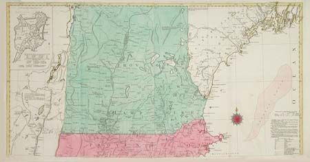
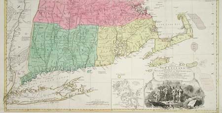
Subject: Colonial New England

Period: 1776 (circa)

Publication:

Color: Hand Color

Size:
See Description
Download High Resolution Image
(or just click on image to launch the Zoom viewer)

A German edition of one of the most detailed, accurate, and certainly most visually impressive, maps of New England. The map was original published by Thomas Jefferys in 1755 and is believed to have been compiled by Braddock Mead, alias John Green. The map includes two fine insets: "A Plan of the Town of Boston" and "A Plan of Boston Harbor" and a superb vignette of the Pilgrim's landing beneath the uncolored cartouche. Engraved on four separate sheets, here partially joined to form two separate sheets. Size would be 38.2 x 40" if joined.

References: McCorkle #776-16; Sellers & Van Ee #801.

Condition: B

Bright original color. Few very insignificant light scattered spots. Expertly remargined at lower left sheet including excellent facsimile of border.

Estimate: $3,500 - $4,000

Sold for: $3,500

Closed on 12/4/2002

Archived