Catalog Archive
Auction 100, Lot 458

"A Chart of the Pacific Ocean from the Equinoctial to the Latitude of 39 1/2 d. No.", Anson, George

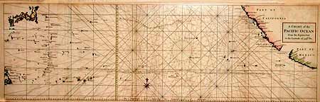
Subject: Pacific Ocean

Period: 1750 (published)

Publication:

Color: Hand Color

Size:
35 x 11 inches
88.9 x 27.9 cm
Download High Resolution Image
(or just click on image to launch the Zoom viewer)

Unusual chart detailing the route of Spanish galleons between the Philippines and Acapulco. The tracks of British Navy Commodore George Anson and Spanish Nostra Seigniora de Cabadonga are shown. Anson captured this galleon, which was loaded with silver and two important maps that detailed the route Manila galleons had followed across the Pacific for almost two hundred years. This capture enabled the British to disrupt this vital Spanish commerce. Good detail of the Pacific islands and the coasts of Baja California and Mexico. Engraved by Richard W. Seale.

References: Mercator's World Nov/Dec 1998 p. 47.

Condition: B

Slight uneven toning and folds reinforced with tissue.

Estimate: $200 - $250

Sold for: $150

Closed on 9/12/2002

Archived