Subject: England
Period: 1675-98 (published)
Publication: Britannia
Color: Hand Color
Size:
17.1 x 12.6 inches
43.4 x 32 cm
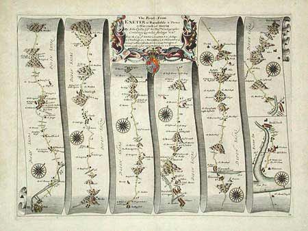
John Ogilby's 'Britannia' was published between 1675 and 1698. It is a landmark in the mapping of England and Wales. Its unique format constituted the first national road-atlas of any country in Western Europe. It was composed of maps of seventy-three major roads and cross-roads, presented in a continuous strip-form, on a uniform scale of one inch to a mile. Each beautiful map includes wonderful detail of the countryside with each strip containing a large compass rose to indicate changes in direction.
Contains 76 miles of roads in Devonshire. Route travels through Crediton Kerton, Chimleigh and Bedford. Locates three beacons in hilly regions, ostensibly for night travel. Eight lovely compass roses in full color. Finely engraved cartouche with gold highlights to the crown.
References:
Condition: B
Finely colored on nice paper with full margins. A little surface soiling, else very good.