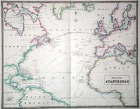
Subject: North Atlantic
Period: 1858 (circa)
Publication:
Color: Hand Color
Size:
25.3 x 20 inches
64.3 x 50.8 cm
The major focus of the chart is the newly created Atlantic Telegraphic Cable with the notation "Cable spliced July 29th 1858 - Completed August 5th 1858." The line is shown with the cable depths along the way. By the middle of the 19th century, a vast network of telegraph lines connected the major population centers in Europe and on the North American mainland. The gulf between them of the 2,000-mile wide Atlantic ocean remained a major challenge to the science and enterprise of the Victorian era. The completion of this communication link between the New World and the Old was a momentous achievement. However, even as its success was celebrated, and this map published, some unknown rupture ruined the cable's conductivity and it was another decade before the telegraph line was successfully completed.
References:
Condition: B
Faint scattered foxing and tiny fold separations repaired with tissue.