Showing Featured Lots(remove filter)
Filtered by Category:United States(Show All Categories)
Showing results for:Auction 179
Catalog Archive
14 lots
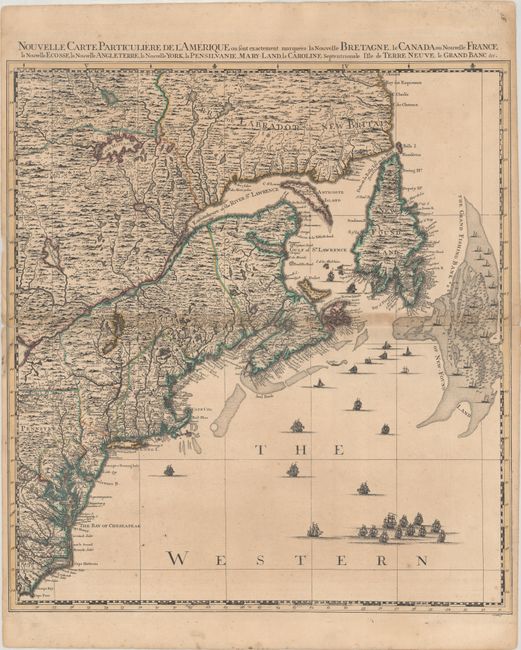
Auction 179, Lot 129
Subject: Colonial Northeastern United States & Canada
Popple/Covens & Mortier
Nouvelle Carte Particuliere de l'Amerique ou sont Exactement Marquees la Nouvelle Bretagne, le Canada ou Nouvelle France, la Nouvelle Ecosse, la Nouvelle Angleterre, la Nouvelle York, la Pensilvanie..., 1741
Size: 20.6 x 22.5 inches (52.3 x 57.2 cm)
Estimate: $2,000 - $2,300
Northeastern Sheet of the Reduced-Size Edition of Popple's Map
Sold for: $1,500
Closed on 9/16/2020
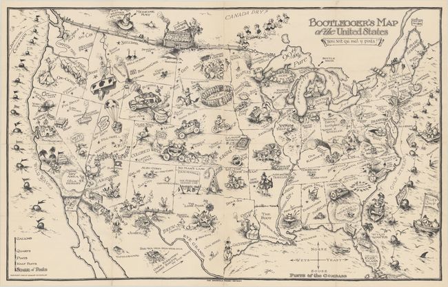
Auction 179, Lot 146
Subject: United States
Bootlegger's Map of the United States, 1926
Size: 33.8 x 21.3 inches (85.9 x 54.1 cm)
Estimate: $1,400 - $1,700
McCandlish's Humorous Prohibition Map
Sold for: $1,000
Closed on 9/16/2020
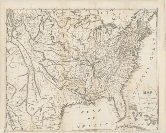
Auction 179, Lot 162
Subject: Eastern United States
Darby, William
A Map of the United States Including Louisiana, 1817
Size: 22.5 x 18.2 inches (57.2 x 46.2 cm)
Estimate: $2,000 - $2,300
Unrecorded State Prior to the Addition of Louisiana
Sold for: $1,200
Closed on 9/16/2020
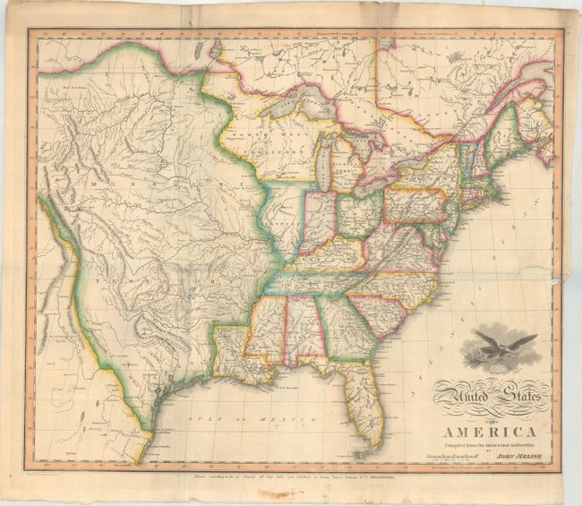
Auction 179, Lot 164
Subject: Eastern United States
Melish, John
United States of America Compiled from the Latest & Best Authorities, 1818
Size: 19.5 x 16.1 inches (49.5 x 40.9 cm)
Estimate: $1,800 - $2,300
Early & Separately Issued Version of Melish's Important Map
Sold for: $3,000
Closed on 9/16/2020
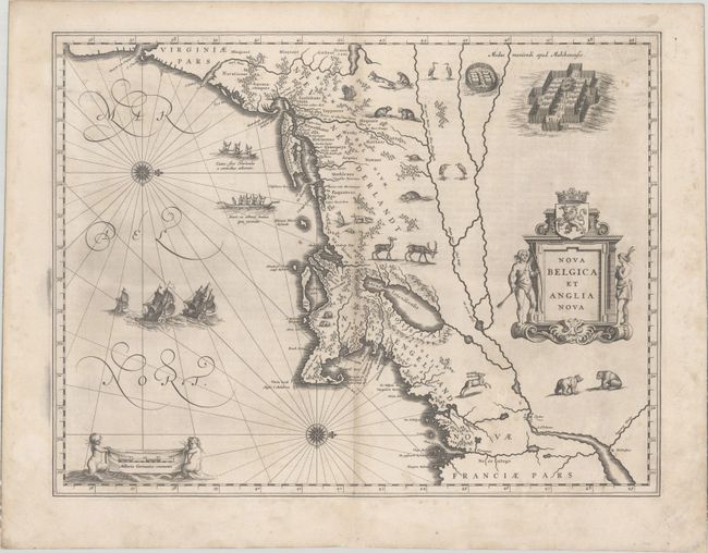
Auction 179, Lot 171
Subject: Colonial New England & Mid-Atlantic United States
Blaeu, Willem
Nova Belgica et Anglia Nova, 1634
Size: 19.9 x 15.3 inches (50.5 x 38.9 cm)
Estimate: $2,000 - $2,300
Important Map of Colonial New England and the Mid-Atlantic - First Edition
Sold for: $1,100
Closed on 9/16/2020
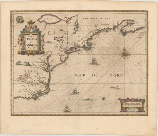
Auction 179, Lot 172
Subject: Colonial New England & Mid-Atlantic United States
Jansson, Jan
Nova Belgica et Anglia Nova, 1646
Size: 19.9 x 15.3 inches (50.5 x 38.9 cm)
Estimate: $1,600 - $1,900
Jansson's Influential Map of the East Coast - in Contemporary Color
Sold for: $1,000
Closed on 9/16/2020
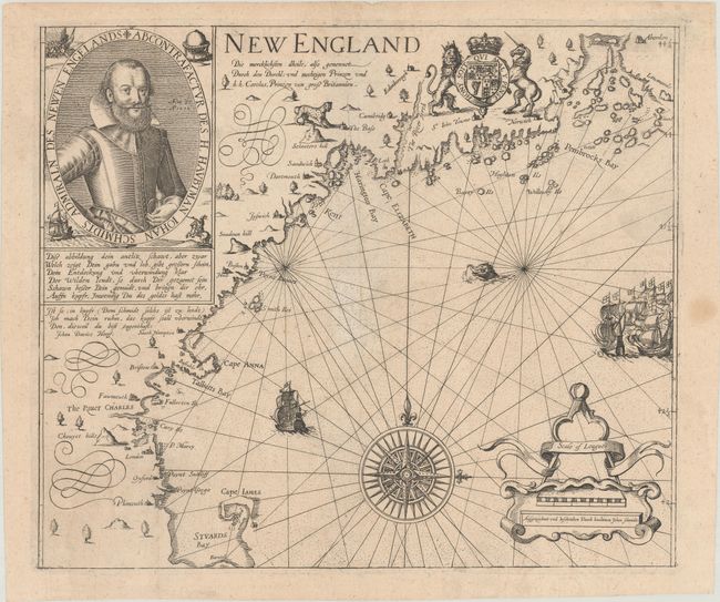
Auction 179, Lot 174
Subject: Colonial New England United States
Smith, John (Capt.)
New England die Mercklichsten Dheile..., 1617
Size: 13.6 x 11.5 inches (34.5 x 29.2 cm)
Estimate: $8,000 - $9,500
German Edition of Capt. John Smith's Foundation Map of New England
Unsold
Closed on 9/16/2020
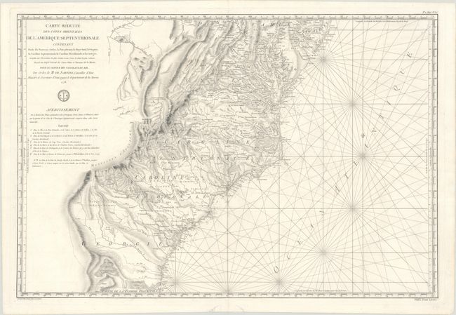
Auction 179, Lot 177
Subject: Colonial Mid-Atlantic & Southeast United States
Sartine
Carte Reduite des Cotes Orientales de l'Amerique Septentrionale Contenant Partie du Nouveau Jersey, la Pen-sylvanie, le Mary-land, la Virginie, la Caroline Septentrionale, la Caroline Meridionale et la Georgie..., 1778
Size: 34.3 x 23.1 inches (87.1 x 58.7 cm)
Estimate: $1,500 - $1,800
Important Revolutionary War-Era Sea Chart of the Colonial Mid-Atlantic and Southeast
Sold for: $1,100
Closed on 9/16/2020
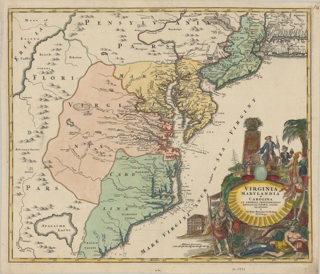
Auction 179, Lot 179
Subject: Colonial Mid-Atlantic United States
Homann, Johann Baptist
Virginia Marylandia et Carolina in America Septentrionali Britannorum Industria Excultae Repraesentatae, 1730
Size: 22.8 x 19.2 inches (57.9 x 48.8 cm)
Estimate: $1,800 - $2,100
Map Created to Promote German Immigration to the New World
Unsold
Closed on 9/16/2020
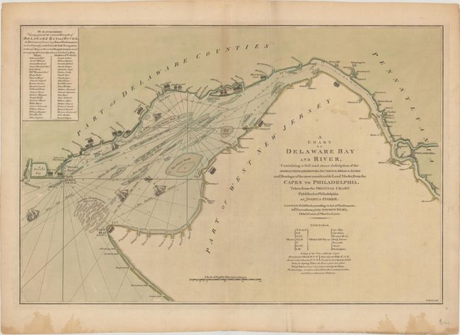
Auction 179, Lot 181
Subject: Colonial Delaware Bay
Dury, Andrew
A Chart of Delaware Bay and River, Containing a Full and Exact Description of the Shores, Creeks, Harbours, Soundings, Shoals, Sands and Bearings of the Most Considerable Land Marks..., 1776
Size: 27.3 x 18 inches (69.3 x 45.7 cm)
Estimate: $2,500 - $3,250
Early Revolutionary War Chart of the Delaware Bay
Sold for: $1,500
Closed on 9/16/2020
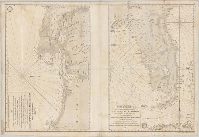
Auction 179, Lot 188
Subject: Colonial Southern United States
Depot de la Marine
Carte d'une Partie des Cotes de la Floride et de la Louisiane... [on sheet with] Carte Reduite des Cotes et de l'Interieur de la Presqu'ile de la Floride, avec le Detroit de Cette Presqu'ile et le Canal de Bahama, 1778-80
Size: 34.3 x 23 inches (87.1 x 58.4 cm)
Estimate: $2,400 - $3,000
Two Important Revolutionary War Charts
Sold for: $1,800
Closed on 9/16/2020
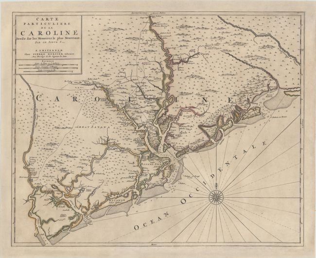
Auction 179, Lot 290
Subject: Colonial South Carolina, Charleston
Sanson/Mortier
Carte Particuliere de la Caroline Dresse sur les Memoires le Plus Nouveaux, 1700
Size: 23.5 x 18.9 inches (59.7 x 48 cm)
Estimate: $3,250 - $4,000
Foundation Map of South Carolina - First State
Sold for: $2,000
Closed on 9/16/2020
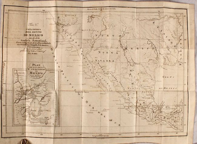
Auction 179, Lot 334
Subject: Southwestern United States & Mexico
Carta Esferica del Reyno de Mexico y Parte de la America Setentrional... [in] Descubrimiento y Conquista de la America, o Compendio de la Historia General del Nuevo Mundo...(Vol 2), 1817
Size: 17.8 x 12.4 inches (45.2 x 31.5 cm)
Estimate: $2,200 - $2,500
A Scarce Spanish Map of the Southwest
Sold for: $1,200
Closed on 9/16/2020
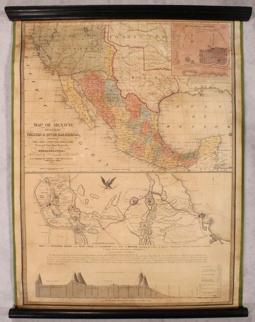
Auction 179, Lot 336
Subject: Southwestern United States & Mexico
Mitchell, Samuel Augustus
Map of Mexico, Including Yucatan & Upper California, Exhibiting the Chief Cities and Towns, the Principal Travelling Routes &c., 1847
Size: 23.6 x 32 inches (59.9 x 81.3 cm)
Estimate: $3,500 - $4,250
Mitchell's Mexican-American War Map
Sold for: $2,500
Closed on 9/16/2020
14 lots