Showing Featured Lots(remove filter)
Filtered by Category:United States(Show All Categories)
Showing results for:Auction 160
Catalog Archive
20 lots
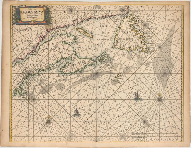
Auction 160, Lot 132
Subject: Canadian Maritimes & New England
Loon, Jan van
Pas-caerte van Terra Nova, Nova Francia, Nieuw Engeland en de Grote Rivier van Canada, 1666
Size: 21.2 x 16.8 inches (53.8 x 42.7 cm)
Estimate: $3,500 - $4,500
Very Influential Dutch Sea Chart of the Canadian Maritimes
Sold for: $1,900
Closed on 11/16/2016
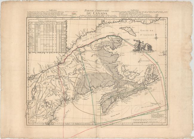
Auction 160, Lot 137
Subject: Colonial Northeastern United States & Canada
Le Rouge, George Louis
Partie Orientale du Canada Traduitte de l'Anglois de la Carte de Jefferys Publiee a Londres..., 1755
Size: 24.1 x 18.6 inches (61.2 x 47.2 cm)
Estimate: $950 - $1,200
Map Depicting French and British Claims in the Canadian Maritimes
Sold for: $600
Closed on 11/16/2016
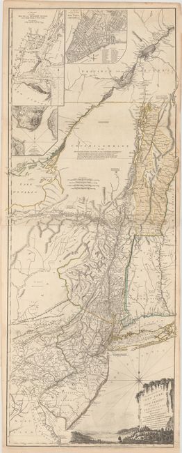
Auction 160, Lot 139
Subject: Colonial Northeastern United States & Quebec
Holland/Pownal
The Provinces of New York and New Jersey; with Part of Pensilvania, and the Province of Quebec, 1776
Size: 21.3 x 52.9 inches (54.1 x 134.4 cm)
Estimate: $5,500 - $7,000
Thomas Jefferys' Important Revolutionary War Period Map
Sold for: $3,500
Closed on 11/16/2016
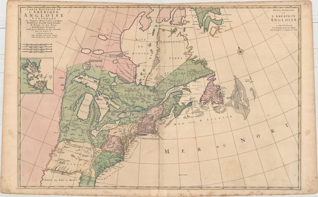
Auction 160, Lot 145
Subject: Colonial Eastern United States & Canada
Mortier, Pierre
Carte Nouvelle de l'Amerique Angloise Contenant la Virginie, Mary-Land, Caroline, Pensylvania Nouvelle Iorck, N: Iarsey N: France, et les Terres Nouvellement Decouerte..., 1700
Size: 35.8 x 23.4 inches (90.9 x 59.4 cm)
Estimate: $2,000 - $2,300
A Map Showing Fascinating Geographic Misconceptions
Sold for: $1,200
Closed on 11/16/2016
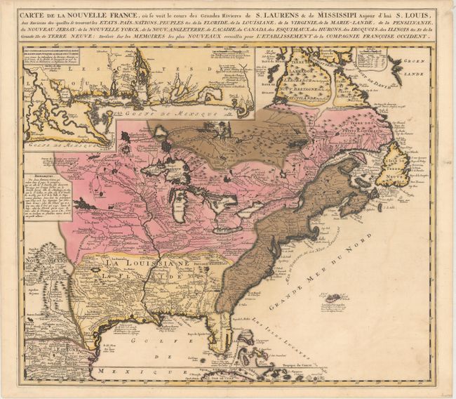
Auction 160, Lot 146
Subject: Colonial Eastern United States & Canada
Ottens/De Fer
Carte de la Nouvelle France, ou se Voit le Cours des Grandes Rivieres de S. Laurens & de Mississipi Aujour d'hui S. Louis, aux Environs des-quelles se Trouvent les Etats, Pais, Nations, Peuples &c..., 1719
Size: 21.5 x 19.5 inches (54.6 x 49.5 cm)
Estimate: $2,300 - $2,750
Reduced Version of De Fer's Influential Map of French Possessions in North America
Sold for: $1,700
Closed on 11/16/2016
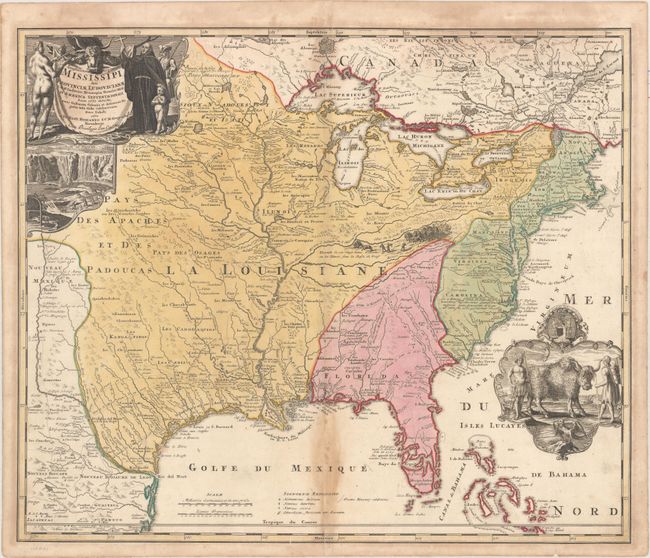
Auction 160, Lot 147
Subject: Colonial Eastern United States & Canada
Homann, Johann Baptist
Amplissimae Regionis Mississipi seu Provinciae Ludovicianae a R.P. Ludovico Hennepin Francisc Miss in America Septentrionali Anno 1687..., 1720
Size: 22.6 x 19.1 inches (57.4 x 48.5 cm)
Estimate: $1,700 - $2,000
Striking Map of Colonial America with Buffalo Vignette
Sold for: $1,400
Closed on 11/16/2016
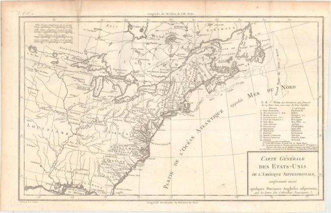
Auction 160, Lot 150
Subject: Eastern United States & Canada
Crevecoeur, Michel Guillaume De
Carte Generale des Etats-Unis de l'Amerique Septentrionale, Renfermant Aussi Quelques Provinces Angloises Adjacentes..., 1787
Size: 16.7 x 10.1 inches (42.4 x 25.7 cm)
Estimate: $800 - $1,000
One of the Earliest Maps to Name Franklinia
Sold for: $600
Closed on 11/16/2016
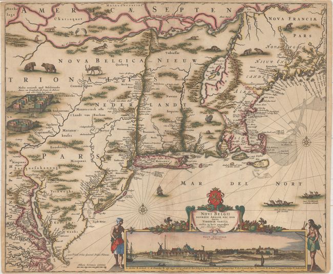
Auction 160, Lot 187
Subject: Colonial New England & Mid-Atlantic United States
Visscher, Nicolas
Novi Belgii Novaeque Angliae nec non Partis Virginiae Tabula Multis in Locis Emendata, 1682
Size: 21.8 x 18.3 inches (55.4 x 46.5 cm)
Estimate: $8,000 - $9,500
Visscher's Influential Map with Early View of New York City - Rare 3rd State Without Philadelphia
Unsold
Closed on 11/16/2016
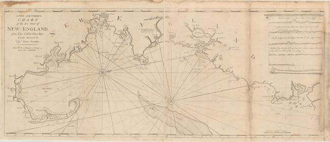
Auction 160, Lot 189
Subject: Colonial New England - United States
Mount & Page
[On 2 Sheets] A New and Correct Chart of the Sea Coast of New-England, from Cape Codd to Casco Bay..., 1764
Size: 23.1 x 18.7 inches (58.7 x 47.5 cm)
Estimate: $2,750 - $3,500
Rare Chart of the Coast of New England by Captain Barnsley
Unsold
Closed on 11/16/2016
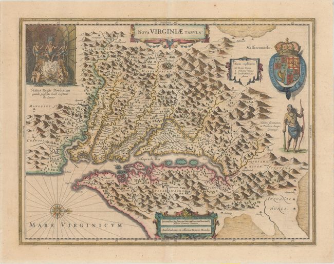
Auction 160, Lot 192
Subject: Colonial Mid-Atlantic United States
Hondius, Henricus
Nova Virginiae Tabula, 1646
Size: 19.5 x 15.1 inches (49.5 x 38.4 cm)
Estimate: $2,000 - $2,300
One of the Most Important 17th Century Maps of the Chesapeake Bay
Unsold
Closed on 11/16/2016
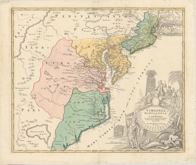
Auction 160, Lot 196
Subject: Colonial Mid-Atlantic United States
Homann, Johann Baptist
Virginia Marylandia et Carolina in America Septentrionali Britannorum Industria Excultae, 1714
Size: 23.1 x 19.3 inches (58.7 x 49 cm)
Estimate: $1,900 - $2,200
Map Created to Promote German Immigration to the New World
Unsold
Closed on 11/16/2016
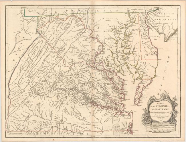
Auction 160, Lot 197
Subject: Colonial Mid-Atlantic United States
Robert de Vaugondy, Didier
Carte de la Virginie et du Maryland Dressee sur la Grande Carte Angloise de Mrs. Josue Fry et Pierre Jefferson, 1755
Size: 25.5 x 19.2 inches (64.8 x 48.8 cm)
Estimate: $2,300 - $2,750
First State of Robert de Vaugondy's Essential Map of Virginia and Maryland
Unsold
Closed on 11/16/2016
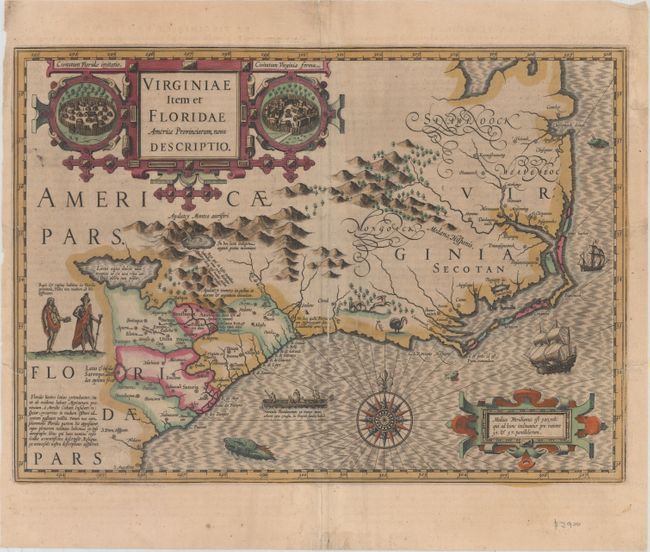
Auction 160, Lot 203
Subject: Colonial Southeastern United States
Hondius, Jodocus
Virginiae Item et Floridae Americae Provinciarum, Nova Descriptio, 1613
Size: 19 x 13.5 inches (48.3 x 34.3 cm)
Estimate: $1,700 - $2,000
A Seminal Map of the Southeast and Early American Cartography
Unsold
Closed on 11/16/2016
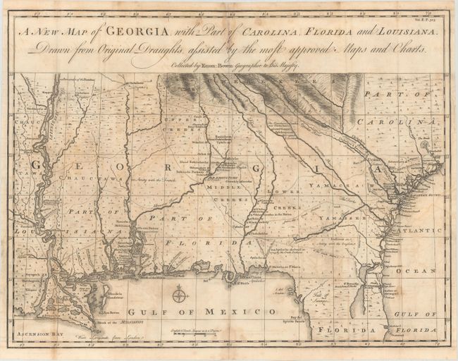
Auction 160, Lot 207
Subject: Colonial Southeastern United States
Bowen, Emanuel
A New Map of Georgia, with Part of Carolina, Florida and Louisiana. Drawn from Original Draughts, Adjusted by the Most Approved Maps and Charts, 1748
Size: 18.9 x 14.3 inches (48 x 36.3 cm)
Estimate: $2,000 - $2,300
Early Map of the Georgia Colony
Sold for: $1,000
Closed on 11/16/2016
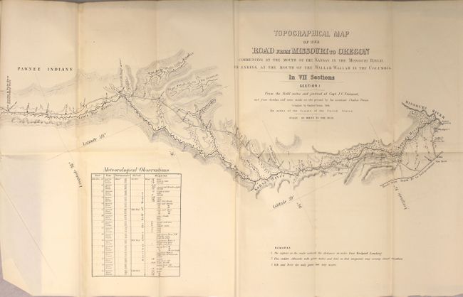
Auction 160, Lot 229
Subject: Western United States
Fremont/Preuss
[On 7 Sheets] Topographical Map of the Road from Missouri to Oregon in Seven Sections [bound in] Report No. 145...Canal or Railroad Between the Atlantic and Pacific Oceans, 1849
Size: 26 x 16 inches (66 x 40.6 cm)
Estimate: $4,000 - $5,000
Scarce Seven Part Oregon Trail Map
Sold for: $2,500
Closed on 11/16/2016
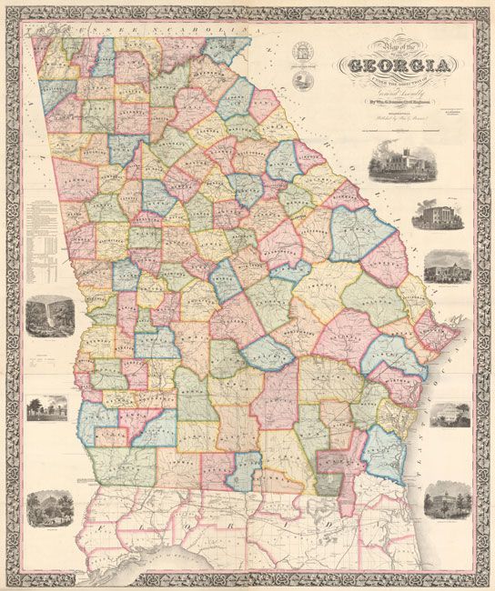
Auction 160, Lot 275
Subject: Georgia
Bonner, William G.
[On 2 Sheets] Map of the State of Georgia Compiled Under the Direction of the General Assembly, 1859
Size: 26.5 x 62.4 inches (67.3 x 158.5 cm)
Estimate: $8,000 - $10,000
Bonner's Landmark Map of Georgia
Sold for: $9,500
Closed on 11/16/2016
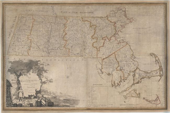
Auction 160, Lot 293
Subject: Massachusetts
Carleton, Osgood
Map of Massachusetts Proper Compiled from Actual Surveys Made by Order of the General Court, and Under the Inspection of Agents of Their Appointment , 1801
Size: 44.9 x 30.3 inches (114 x 77 cm)
Estimate: $11,000 - $13,000
Landmark Map of Massachusetts - First Edition of the First Official Map of the State
Unsold
Closed on 11/16/2016
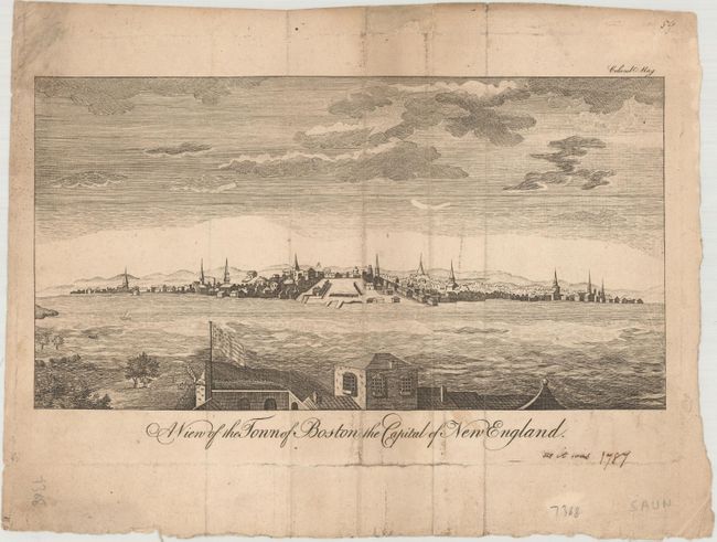
Auction 160, Lot 298
Subject: Boston, Massachusetts
A View of the Town of Boston the Capital of New England, 1787
Size: 9.2 x 4.9 inches (23.4 x 12.4 cm)
Estimate: $700 - $850
Rare Edition of Boston View with American Flag
Sold for: $400
Closed on 11/16/2016
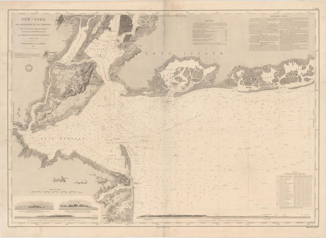
Auction 160, Lot 312
Subject: New York Bay & Bight
Depot de la Marine
New-York ses Mouillages et ses Atterages..., 1854
Size: 34.8 x 24.3 inches (88.4 x 61.7 cm)
Estimate: $2,000 - $2,300
Rare Large Chart of New York Bay and Bight
Unsold
Closed on 11/16/2016

Auction 160, Lot 336
Subject: Virginia
Bucholtz, Ludwig von
Map of the State of Virginia Containing the Counties, Principal Towns, Railroads Rivers, Canals & All Other Internal Improvements, 1858
Size: 37.8 x 25.5 inches (96 x 64.8 cm)
Estimate: $7,500 - $9,000
First Edition Bucholtz Map of Virginia
Sold for: $6,500
Closed on 11/16/2016
20 lots