Showing Featured Lots(remove filter)
Filtered by Category:United States(Show All Categories)
Showing results for:Auction 149
Catalog Archive
20 lots
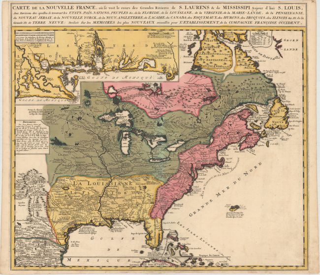
Auction 149, Lot 109
Subject: Colonial United States & Canada
Ottens/De Fer
Carte de la Nouvelle France, ou se Voit le Cours des Grandes Rivieres de S. Laurens & de Mississipi Aujour d'hui S. Louis..., 1745
Size: 21.6 x 19.5 inches (54.9 x 49.5 cm)
Estimate: $2,300 - $2,600
Reduced Version of De Fer's Influential Map of French Possessions in North America
Sold for: $1,700
Closed on 5/21/2014
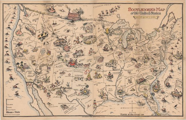
Auction 149, Lot 129
Subject: United States
Bootlegger's Map of the United States, 1926
Size: 32 x 22 inches (81.3 x 55.9 cm)
Estimate: $1,100 - $1,400
McCandish's Humorous Prohibition Map
Sold for: $800
Closed on 5/21/2014
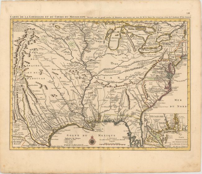
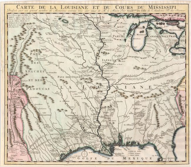
Auction 149, Lot 130
Subject: Colonial United States, Louisiana Territory
Delisle/Covens & Mortier
Carte de la Louisiane et du Cours du Mississipi Dressee sur un Grand Nombre de Memoires entr'autres sur ceux de Mr. le Maire, 1733
Size: 23.4 x 17.2 inches (59.4 x 43.7 cm)
Estimate: $2,750 - $3,500
Delisle's Influential Map of the Louisiana Territory
Sold for: $2,750
Closed on 5/21/2014
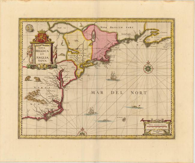
Auction 149, Lot 140
Subject: Colonial New England & Mid-Atlantic
Jansson/Valck & Schenk
Nova Belgica et Anglia Nova, 1694
Size: 19.5 x 15 inches (49.5 x 38.1 cm)
Estimate: $2,200 - $2,400
Jansson's Influential Map of the East Coast
Sold for: $1,500
Closed on 5/21/2014
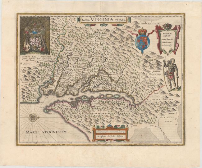
Auction 149, Lot 144
Subject: Colonial Mid-Atlantic United States
Hondius/Blaeu
Nova Virginiae Tabula, 1642
Size: 18.9 x 14.8 inches (48 x 37.6 cm)
Estimate: $2,750 - $3,500
One of the Most Important 17th Century Maps of the Chesapeake Bay - Full Original Color
Sold for: $1,850
Closed on 5/21/2014
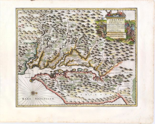
Auction 149, Lot 145
Subject: Colonial Mid-Atlantic United States
Aa, Pieter van der
Virginie, Grande Region de l'Amerique Septentrionale, avec Tous Ses Bourgs, Hameaux, Rivieres et Bayes, Suivant les Recherches Exactes de Ceux qui l'ont Decouverte, et Nouvellement Mise au Jour, 1729
Size: 14.1 x 11.4 inches (35.8 x 29 cm)
Estimate: $1,800 - $2,000
Rare Derivative of John Smith's Map of the Chesapeake Bay
Sold for: $1,300
Closed on 5/21/2014
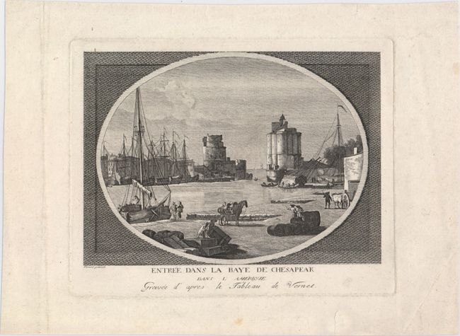
Auction 149, Lot 154
Subject: Colonial Chesapeake Bay
Anon.
Entree dans la Baye de Chesapeak dans l'Amerique, 1775
Size: 8.3 x 5.9 inches (21.1 x 15 cm)
Estimate: $160 - $200
Imaginary View of the Entrance to the Chesapeake Bay During the Revolutionary War
Sold for: $325
Closed on 5/21/2014
Auction 149, Lot 170
Subject: Colonial Central & Southern United States
Delisle, Guillaume
Carte de la Louisiane et du Cours du Mississipi Dressee sur un Grand Nombre de Memoires..., 1727
Size: 16.2 x 14 inches (41.1 x 35.6 cm)
Estimate: $2,000 - $2,300
Reduced-Size Edition of Delisle's Influential Map of the Louisiana Territory
Unsold
Closed on 5/21/2014
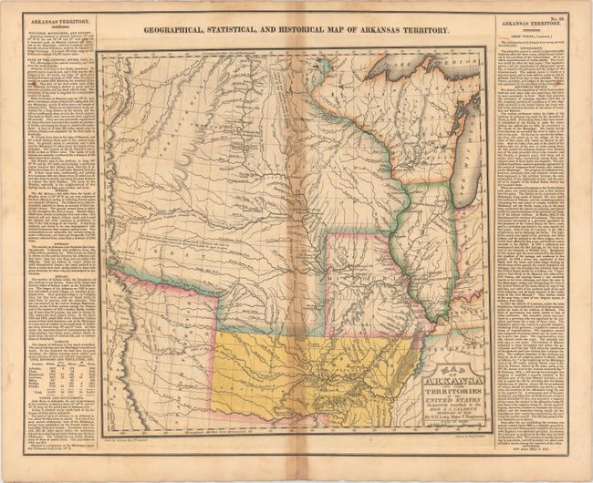
Auction 149, Lot 174
Subject: Central United States, Arkansas
Carey & Lea
Geographical, Statistical, and Historical Map of Arkansas Territory, 1822
Size: 14.7 x 14.5 inches (37.3 x 36.8 cm)
Estimate: $900 - $1,100
Important Map of "Arkansa" and Surroundings
Sold for: $650
Closed on 5/21/2014
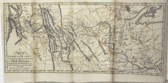
Auction 149, Lot 185
Subject: Western United States
Lewis & Clark
A Map of Lewis and Clark's Track, Across the Western Portion of North America from the Mississippi to the Pacific Ocean... [with] History of the Expedition Under the Command of Captains Lewis and Clarke, to the Sources of the Missouri…[Vol 1 Only], 1817
Size: 13.7 x 6.1 inches (34.8 x 15.5 cm)
Estimate: $6,500 - $8,000
Reduced Version of Lewis & Clark's Famous Map
Sold for: $7,500
Closed on 5/21/2014
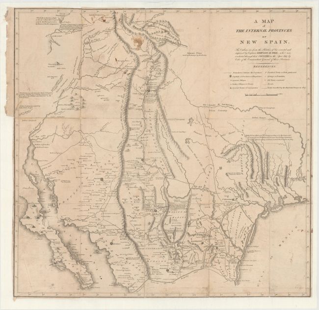
Auction 149, Lot 198
Subject: Southwestern United States
Pike, Zebulon
A Map of the Internal Provinces of New Spain, 1810
Size: 18.6 x 18 inches (47.2 x 45.7 cm)
Estimate: $3,500 - $4,500
A Cornerstone Map of Early Western Exploration
Sold for: $3,250
Closed on 5/21/2014
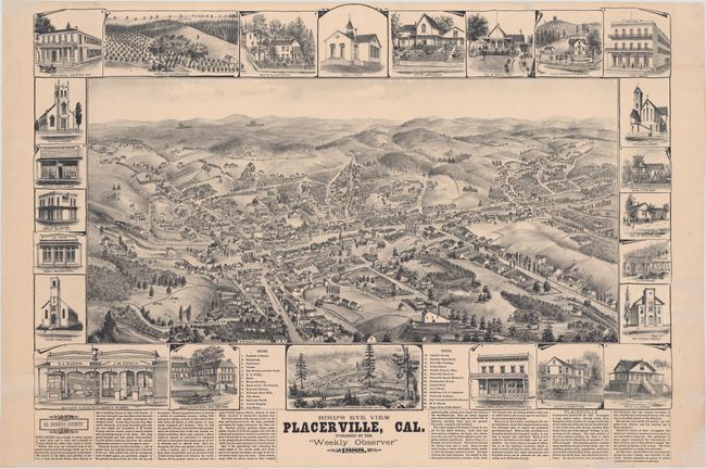
Auction 149, Lot 219
Subject: Placerville, California
Elliott, Wallace W.
Bird's Eye View Placerville, Cal., 1888
Size: 29 x 21 inches (73.7 x 53.3 cm)
Estimate: $2,750 - $3,500
View of California Gold Rush Town
Unsold
Closed on 5/21/2014
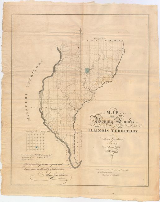
Auction 149, Lot 240
Subject: Western Illinois
Gardiner, John
Map of the Bounty Lands in Illinois Territory, 1818
Size: 14.9 x 18.6 inches (37.8 x 47.2 cm)
Estimate: $2,750 - $3,500
One of the Earliest Maps of Illinois
Sold for: $2,000
Closed on 5/21/2014
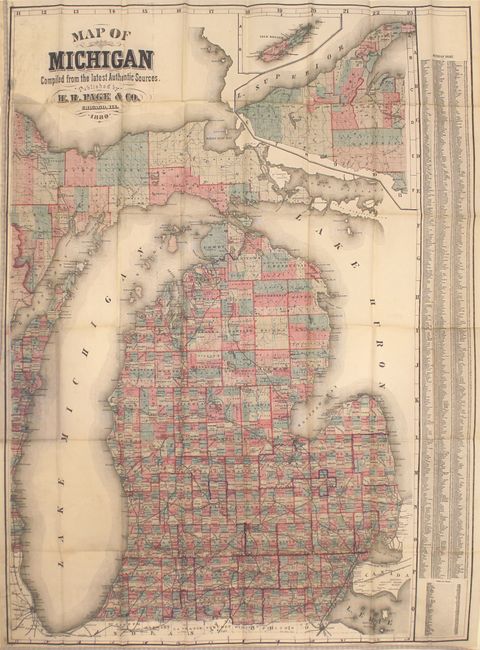
Auction 149, Lot 252
Subject: Michigan
Page, H. R.
Map of Michigan Compiled from the Latest Authentic Sources, 1880
Size: 24 x 36.5 inches (61 x 92.7 cm)
Estimate: $750 - $1,000
Rare Pocket Map of Michigan
Sold for: $550
Closed on 5/21/2014
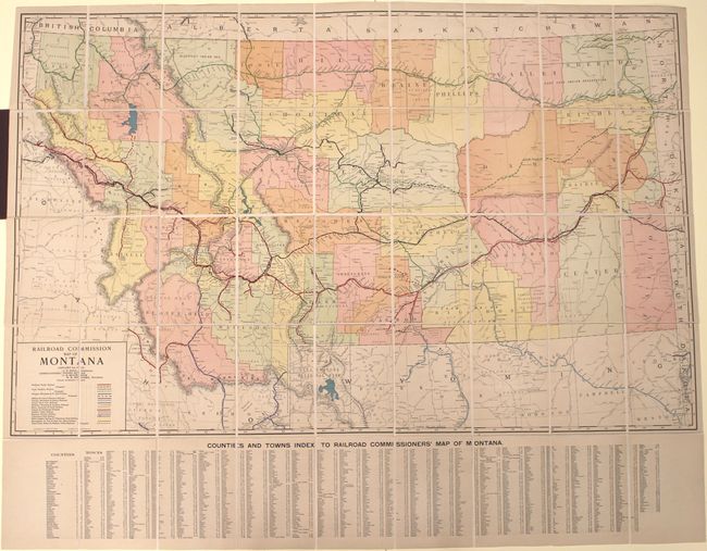
Auction 149, Lot 257
Subject: Montana, Railroads
Rand McNally & Co.
Railroad Commission Map of Montana, 1917
Size: 51.4 x 32.3 inches (130.6 x 82 cm)
Estimate: $900 - $1,100
Large, Attractive Railroad Map of Montana
Unsold
Closed on 5/21/2014
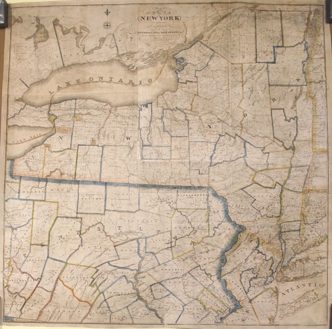
Auction 149, Lot 262
Subject: New York & Pennsylvania
Lay, Amos
Map of the State of New-York with Part of the States of Pennsylvania, New-Jersey &c., 1819
Size: 50.1 x 50 inches (127.3 x 127 cm)
Estimate: $3,000 - $3,750
Rare Wall Map of the State of New York
Unsold
Closed on 5/21/2014
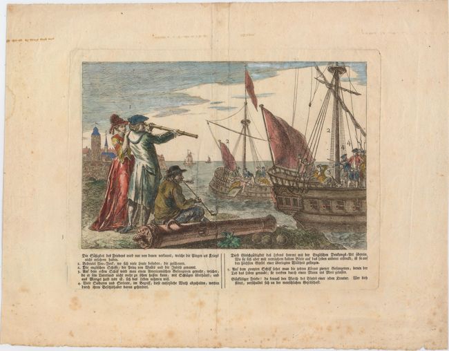
Auction 149, Lot 267
Subject: New York City, New York
Anon.
Die Sussigkeit des Friedens Wird Nur von Denen Verkannt, Welche die Plagen des Kriegs Nicht Erfahren Haben, 1790
Size: 10.1 x 6.7 inches (25.7 x 17 cm)
Estimate: $600 - $800
The Infamous British Prison Ships of the Revolutionary War
Unsold
Closed on 5/21/2014
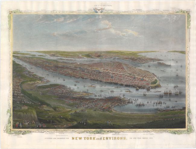
Auction 149, Lot 269
Subject: New York City, New York
Shannon, Joseph
New York and Environs, 1868
Size: 16.6 x 11.3 inches (42.2 x 28.7 cm)
Estimate: $1,000 - $1,300
Rare View of New York City
Sold for: $750
Closed on 5/21/2014
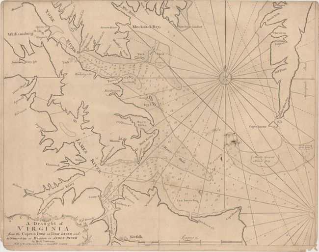
Auction 149, Lot 299
Subject: Eastern Virginia
Mount & Page
A Draught of Virginia from the Capes to York in York River and to Kuiquotan or Hamton in James River, 1751
Size: 23 x 18.1 inches (58.4 x 46 cm)
Estimate: $1,000 - $1,300
First Published Regional Map of Virginia
Sold for: $700
Closed on 5/21/2014
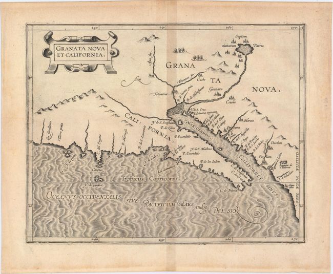
Auction 149, Lot 309
Subject: Southwestern United States & Mexico
Wytfliet, Cornelis
Granata Nova et California, 1597
Size: 11.4 x 9.1 inches (29 x 23.1 cm)
Estimate: $2,400 - $3,000
First Printed Map to Focus on California and the Southwest
Sold for: $2,500
Closed on 5/21/2014
20 lots