Showing Featured Lots(remove filter)
Filtered by Category:Europe & Mediterranean(Show All Categories)
Showing results for:Auction 190
Catalog Archive
10 lots
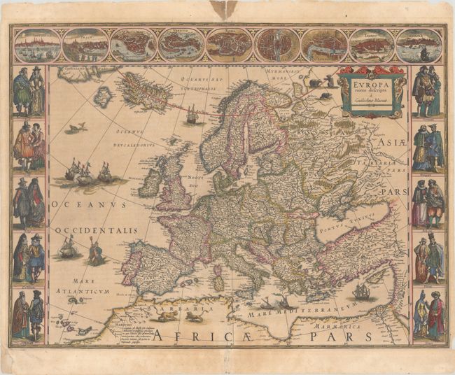
Auction 190, Lot 325
Subject: Europe
Blaeu, Willem
Europa Recens Descripta, 1635
Size: 21.9 x 16.1 inches (55.6 x 40.9 cm)
Estimate: $2,750 - $3,500
Blaeu's Carte-a-Figures Map of Europe in Full Contemporary Color
Sold for: $2,200
Closed on 11/16/2022
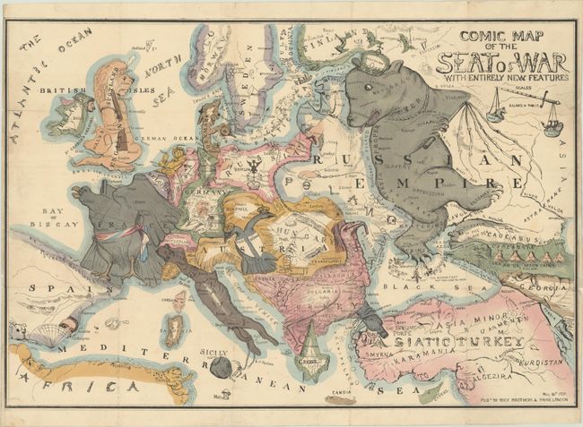
Auction 190, Lot 327
Subject: Europe
Comic Map of the Seat of War with Entirely New Features, 1854
Size: 26.8 x 18.3 inches (68.1 x 46.5 cm)
Estimate: $3,500 - $4,250
Earliest Serio-Comic War Map of Europe
Sold for: $1,750
Closed on 11/16/2022
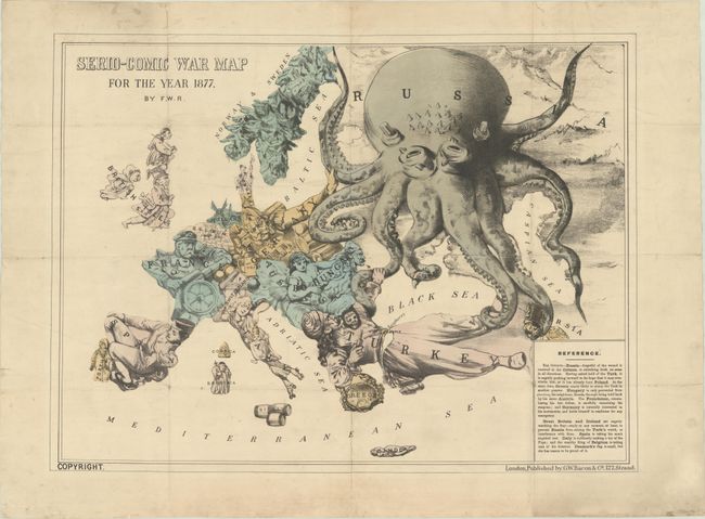
Auction 190, Lot 328
Subject: Europe
Rose, F. W.
Serio-Comic War Map for the Year 1877, 1877
Size: 22.4 x 16.7 inches (56.9 x 42.4 cm)
Estimate: $3,500 - $4,250
Very Rare First Edition, First State of Fred W. Rose's Iconic "Octopus" Map
Sold for: $1,750
Closed on 11/16/2022
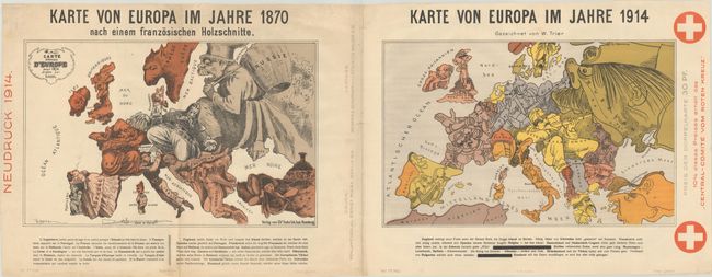
Auction 190, Lot 329
Subject: Europe, World War I
Karte von Europa im Jahre 1870 nach einem Franzosischen Holzschnitte / Karte von Europa im Jahre 1914, 1914
Size: 36.5 x 14 inches (92.7 x 35.6 cm)
Estimate: $1,400 - $1,700
Superb Pair of Satirical Maps Showing Political Changes in Europe from 1870-1914
Sold for: $700
Closed on 11/16/2022
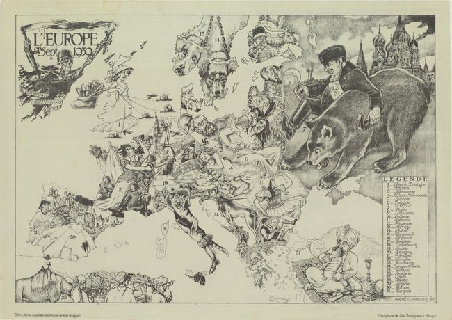
Auction 190, Lot 330
Subject: Europe, World War II
L'Europe en Sept 1939, 1939
Size: 32.7 x 22.5 inches (83.1 x 57.2 cm)
Estimate: $7,500 - $8,500
Rare Example of Limited Edition Serio-Comic Map Depicting Outset of World War II
Sold for: $3,250
Closed on 11/16/2022
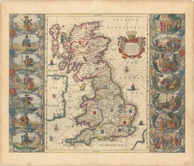
Auction 190, Lot 332
Subject: Britain
Jansson, Jan
Britannia Prout Divisa suit Temporibus Anglo-Saxonum, Praesertim Durante Illorum Heptarchia, 1684
Size: 20.8 x 16.6 inches (52.8 x 42.2 cm)
Estimate: $1,400 - $1,700
Jansson's Splendid Heptarchy Map
Unsold
Closed on 11/16/2022
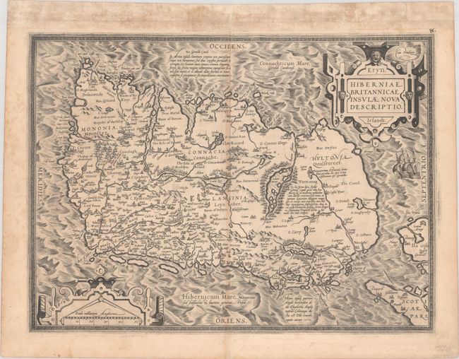
Auction 190, Lot 370
Subject: Ireland
Ortelius, Abraham
Eryn. Hiberniae, Britannicae Insulae, Nova Descriptio. Irlandt, 1573
Size: 19.1 x 14 inches (48.5 x 35.6 cm)
Estimate: $1,200 - $1,500
Ortelius' First Map of Ireland from First Edition Containing this Map
Sold for: $900
Closed on 11/16/2022
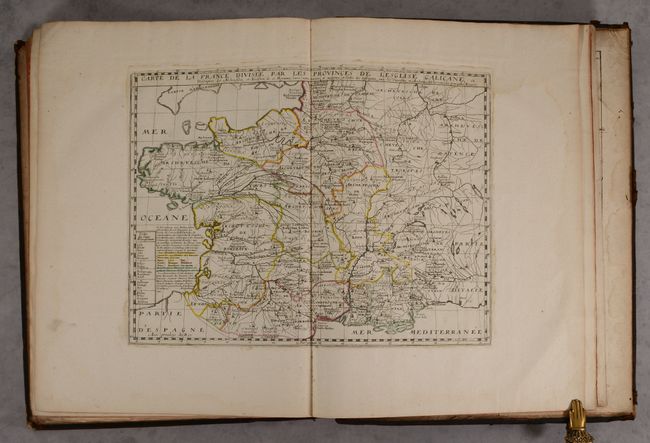
Auction 190, Lot 407
Subject: France & Belgium, Atlases
Sanson/Mariette
Cartes Geographiques des Gaules et de la France , 1707
Size: 16.4 x 21.3 inches (41.7 x 54.1 cm)
Estimate: $4,000 - $5,000
Elephant Folio Atlas with 121 Maps in Contemporary Color
Sold for: $2,500
Closed on 11/16/2022
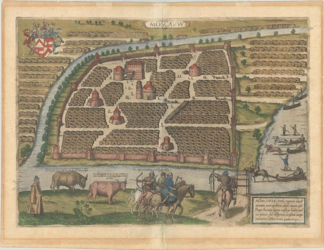
Auction 190, Lot 488
Subject: Moscow, Russia
Braun & Hogenberg
Moscauw, 1597
Size: 19.1 x 13.7 inches (48.5 x 34.8 cm)
Estimate: $2,750 - $3,500
Braun & Hogenberg's First Plan of Moscow in Full Contemporary Color
Sold for: $1,500
Closed on 11/16/2022
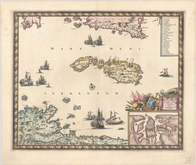
Auction 190, Lot 526
Subject: Malta
Wit, Frederick de
Insula Malta Accuratissime Delineata, Urbibus, et Fortalitiis, 1680
Size: 21.5 x 17.6 inches (54.6 x 44.7 cm)
Estimate: $1,200 - $1,500
One of the Most Decorative 17th Century Maps of Malta
Unsold
Closed on 11/16/2022
10 lots