Showing Featured Lots(remove filter)
Filtered by Category:Europe & Mediterranean(Show All Categories)
Showing results for:Auction 179
Catalog Archive
8 lots
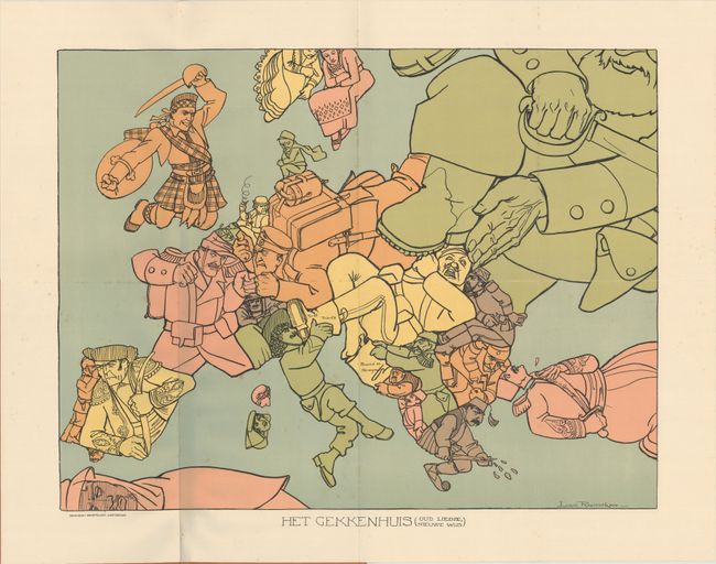
Auction 179, Lot 458
Subject: Europe, World War I
Het Gekkenhuis (Oud Liedje, Nieuwe Wijs), 1914
Size: 20.4 x 15.8 inches (51.8 x 40.1 cm)
Estimate: $1,100 - $1,400
Rare Dutch Satirical Map of World War I
Sold for: $550
Closed on 9/16/2020
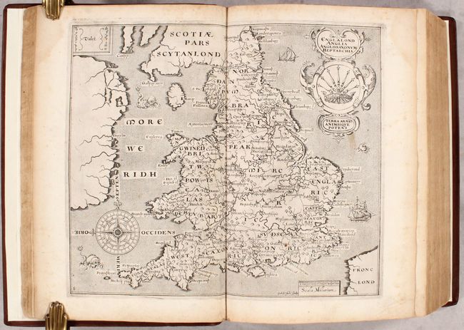
Auction 179, Lot 464
Subject: Britain, Atlas
Camden, William
Britain, or a Chorographicall Description of the Most Flourishing Kingdomes, England, Scotland, and Ireland..., 1610
Size: 9 x 13.3 inches (22.9 x 33.8 cm)
Estimate: $5,000 - $6,500
1610 Edition of Camden's Britannia with 57 Maps by Kip and Hole
Sold for: $3,750
Closed on 9/16/2020
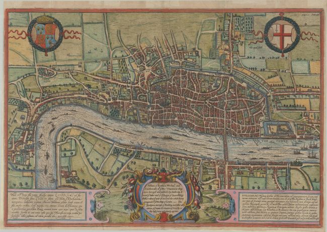
Auction 179, Lot 478
Subject: London, England
Braun & Hogenberg
A Plan of London Westmr. and Southwark wth ye Rivr Thames as They Were Survey'd and Publish't by Authority..., 1708
Size: 19.1 x 13.1 inches (48.5 x 33.3 cm)
Estimate: $2,750 - $3,500
Fourth State of Braun & Hogenberg's Plan of London
Unsold
Closed on 9/16/2020
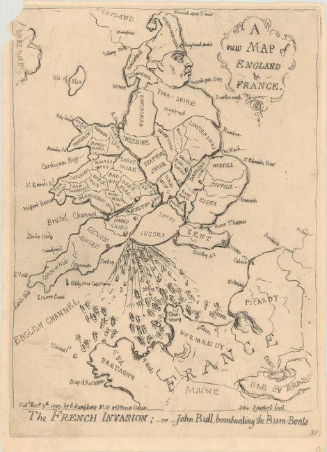
Auction 179, Lot 483
Subject: England, Wales, & France
A New Map of England & France / The French Invasion; - or - John Bull, Bombarding the Bum-Boats, 1851
Size: 9.8 x 12.9 inches (24.9 x 32.8 cm)
Estimate: $800 - $950
Caricature Map Spoofing British/French Relations
Sold for: $450
Closed on 9/16/2020
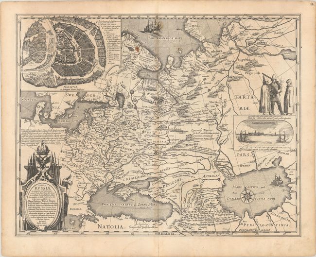
Auction 179, Lot 600
Subject: Russia in Europe
Blaeu, Willem
Tabula Russiae ex Autographo, quod Delineandum Curavit Foedor Filius Tzaris Boris Desumpta ... M.DC.XIIII, 1634
Size: 21.6 x 16.8 inches (54.9 x 42.7 cm)
Estimate: $2,000 - $2,300
Blaeu's Decorative Map of Russia
Unsold
Closed on 9/16/2020
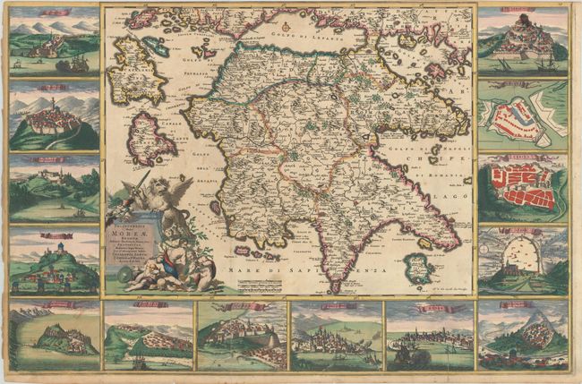
Auction 179, Lot 621
Subject: Southern Greece
Wit, Frederick de
Peloponnesus Hodie Moreae Regnum, Distincte Divisum, in Omnes suas Provincias..., 1690
Size: 29.9 x 19.7 inches (75.9 x 50 cm)
Estimate: $2,500 - $3,250
A Spectacular Map of Peloponessos
Sold for: $1,800
Closed on 9/16/2020
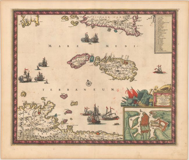
Auction 179, Lot 654
Subject: Malta
Wit, Frederick de
Insula Malta Accuratissime Delineata, Urbibus, et Fortalitiis, 1680
Size: 21.1 x 17.4 inches (53.6 x 44.2 cm)
Estimate: $1,200 - $1,500
One of the Most Decorative 18th Century Maps of Malta
Unsold
Closed on 9/16/2020
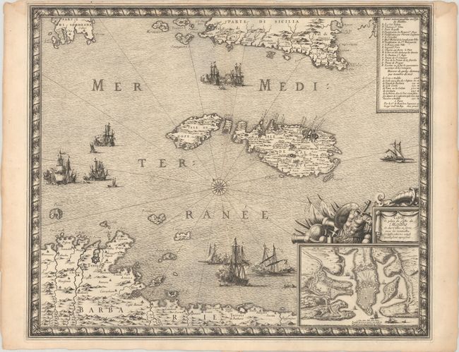
Auction 179, Lot 655
Subject: Malta
Beaulieu, Sebastian de Pontault
Carte et Plan de l'Isle de Malthe et des Villes et Forts avec les Nouvelles Fortiffications Ainsy quelle sont Apresent, 1680
Size: 21.2 x 17.5 inches (53.8 x 44.5 cm)
Estimate: $1,400 - $1,700
Rare and Decorative Map of Malta
Sold for: $700
Closed on 9/16/2020
8 lots