Showing Featured Lots(remove filter)
Filtered by Category:Europe & Mediterranean(Show All Categories)
Showing results for:Auction 168
Catalog Archive
11 lots
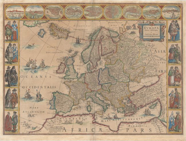
Auction 168, Lot 418
Subject: Europe
Blaeu, Willem
Europa Recens Descripta, 1643
Size: 21.8 x 16.1 inches (55.4 x 40.9 cm)
Estimate: $2,400 - $3,000
Blaeu's Carte-a-Figures Map of Europe
Sold for: $1,800
Closed on 6/6/2018
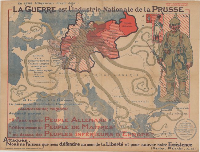
Auction 168, Lot 422
Subject: Europe
La Guerre est l'Industrie Nationale de la Prusse, 1917
Size: 30.4 x 23.2 inches (77.2 x 58.9 cm)
Estimate: $1,200 - $1,600
Rare French Propaganda Map Showing Prussian Octopus
Sold for: $850
Closed on 6/6/2018
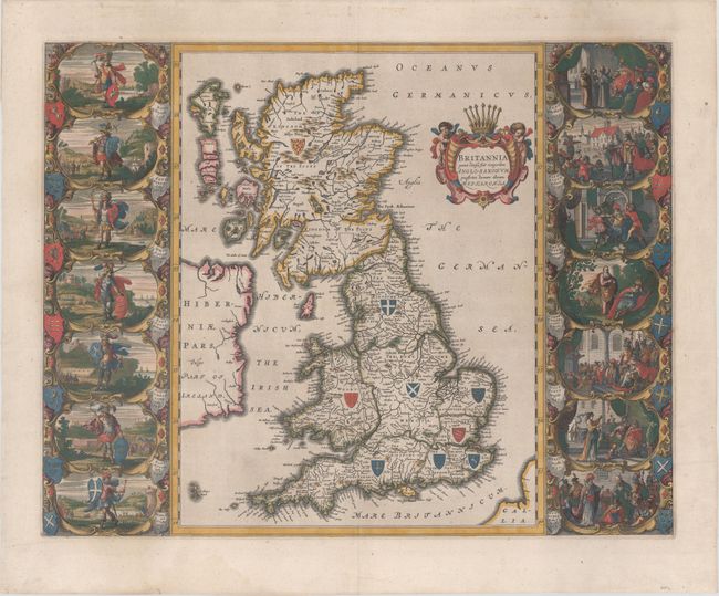
Auction 168, Lot 426
Subject: Britain
Blaeu, Johannes
Britannia Prout Divisa suit Temporibus Anglo-Saxonum, Praesertim Durante Illorum Heptarchia, 1645
Size: 20.8 x 16.3 inches (52.8 x 41.4 cm)
Estimate: $3,000 - $4,000
Decorative Map of Britain with Vignettes of Saxon History
Sold for: $2,200
Closed on 6/6/2018
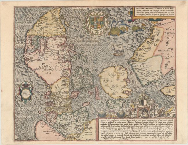
Auction 168, Lot 458
Subject: Denmark
Braun & Hogenberg
Danorum Marca, uel Cimbricum, aut Daniae Regnum..., 1620
Size: 18.3 x 15.1 inches (46.5 x 38.4 cm)
Estimate: $1,900 - $2,200
The Only Map in Braun and Hogenberg's Atlas of Town Views
Sold for: $1,300
Closed on 6/6/2018
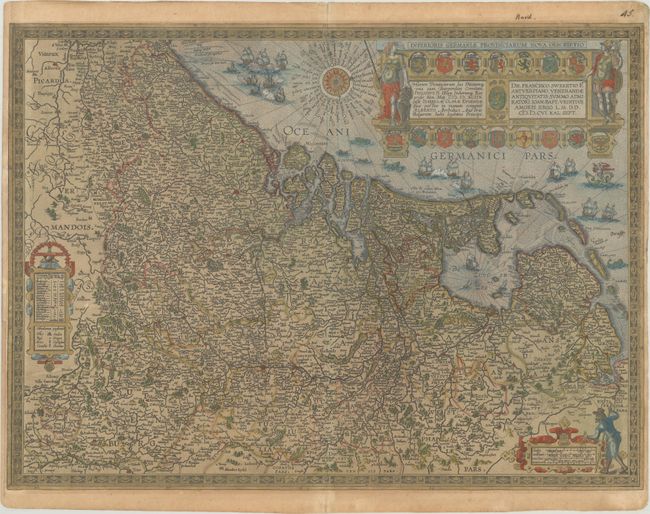
Auction 168, Lot 467
Subject: Low Countries
Ortelius, Abraham
Inferioris Germaniae Provinciarum Nova Descriptio, 1609
Size: 22.1 x 16.3 inches (56.1 x 41.4 cm)
Estimate: $1,500 - $1,800
Rare Decorative Map of the Low Countries in Contemporary Color
Unsold
Closed on 6/6/2018
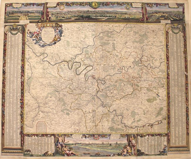
Auction 168, Lot 483
Subject: Paris, France
Nolin, Jean Batiste
Les Environs de Paris, ou sont la Prevoste, Vicomte, et le Presidial de Paris..., 1748
Size: 55.8 x 46.4 inches (141.7 x 117.9 cm)
Estimate: $2,500 - $3,250
Impressive Wall Map of Paris and Surrounding Area
Sold for: $1,700
Closed on 6/6/2018
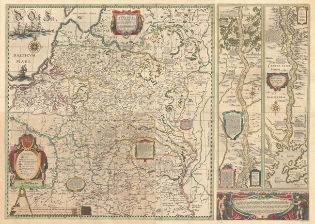
Auction 168, Lot 526
Subject: Eastern Europe, Lithuania
Blaeu, Willem
[6-Sheet Wall Map of Lithuania] Magni Ducatus Lithuaniae, Caeterarumque Regionum Illi Adiacentium Exacta Descriptio... [and] Lectori S. Hunc Borysthenis Tractum ut ad Nostram Geographiae Tabulam…, 1641
Size: See Description
Estimate: $5,500 - $7,000
Impressive Wall Map of the Grand Duchy of Lithuania and the Dnieper River
Sold for: $4,750
Closed on 6/6/2018
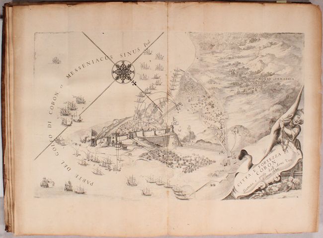
Auction 168, Lot 546
Subject: Southern Greece
Coronelli, Vincenzo Maria
Description Geographique, et Historique de la Moree, Reconquise par les Venitiens. du Royaume de Negrepont..., 1687
Size: 9.9 x 14.9 inches (25.1 x 37.8 cm)
Estimate: $2,750 - $3,500
Attractive Plates of Southern Greece
Sold for: $1,700
Closed on 6/6/2018
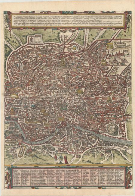
Auction 168, Lot 571
Subject: Rome, Italy
Braun & Hogenberg
Antiquae Urbis Romae Imago Accuratiss: ex Vetustis Monumentis, ex Vestigiis Videlicet Aedificior..., 1620
Size: 19.6 x 27 inches (49.8 x 68.6 cm)
Estimate: $1,600 - $2,000
Superb, Two-Sheet Bird's-Eye Plan of Rome
Sold for: $1,200
Closed on 6/6/2018

Auction 168, Lot 572
Subject: Rome, Italy
All' Altezza Reale Eminentissima di Errigo Benedetto Maria Vescovo di Frascati Cardinal Duca d'Yorck ... Il Prospetto Principale del Tempio e Piazza di S. Pietro in Vaticano, e Palazzo Pontificio..., 1774
Size: 38.2 x 27.7 inches (97 x 70.4 cm)
Estimate: $1,600 - $2,000
Stunning, Large-Scale View of St. Peter's Basilica by Vasi
Sold for: $1,100
Closed on 6/6/2018
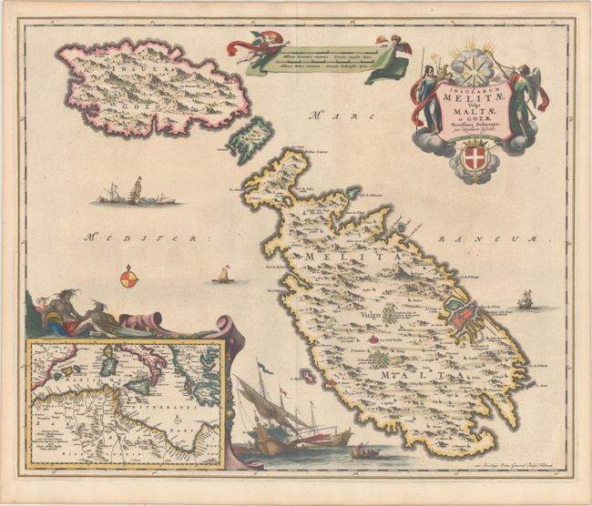
Auction 168, Lot 577
Subject: Malta
Visscher, Nicolas
Insularum Melitae Vulgo Maltae et Gozae Novissima Delineatio, 1680
Size: 22.1 x 18.3 inches (56.1 x 46.5 cm)
Estimate: $1,600 - $1,900
Highly Decorative, 17th Century Map of Malta
Unsold
Closed on 6/6/2018
11 lots