Subject: Eastern Europe, Lithuania
Period: 1641 (circa)
Publication:
Color: Hand Color
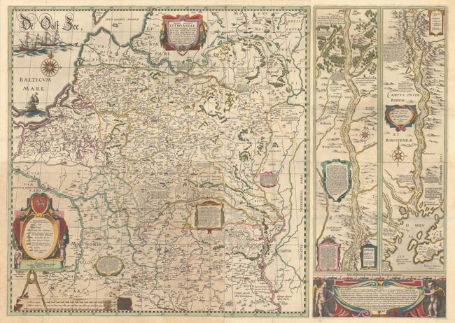
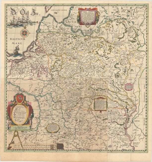
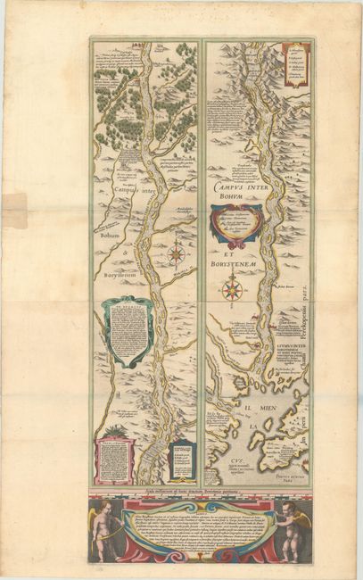
This superb and matching set of maps are based on an important map of the Duchy of Lithuania commissioned by Prince Michael Radziwill in 1586. The map was the most accurate map of Lithuania and served as a resource for all other maps of the region for 150 years. Blaeu first published his four-sheet map of Lithuania along with a two-sheet map of the Dnieper River in 1613 with the imprint "Guilhelmus Janssonius" below the legend at bottom left. He later added the name "Blaeu" to his name in order to differentiate himself from his rival, Jan Jansson. These maps of Lithuania and the Dnieper River, which had been engraved by Hessel Gerritsz, first appeared in Blaeu's atlases in his Appendix in 1631, and were subsequently published in various editions through 1670. It is very rare to find both maps together in a matching set.
The wall map of the Grand Duchy of Lithuania (28.6 x 29.3") was published on two full sheets and two half sheets, and covers the region from Riga to Smolensk in the north, and from Cracow to Kiev in the south. The map provides an incredible amount of information on hundreds of cities and towns of all sizes, political boundaries, and the extensive system of rivers in the region. Also included are a number of historical notations and two vignettes illustrating important battles west of Smolensk and between Braclaw (Bratslav) and Cherkasy (at bottom right). The map is handsomely embellished with several cartouches, three galleons and a sea monster in the Baltic Sea, a large compass rose, and a distance scale on parchment with a caliper. Blank verso.
The map detailing the course of the Dnieper River (12.6 x 29.4") extends from Cherkasy to the estuary on the Black Sea. The map is in strip style with two vertical maps following the course of the river, each decorated with cartouches and compass roses and including numerous lengthy notations describing the cataracts, cities, salt mines, fortresses, and the historical traditions of the Kozaks. Putti flank a large cartouche at bottom. German text on verso. Two sheets joined.
References: Ukraine in Old Maps pp. 188-89; Van der Krogt (Vol. II) #1730/I:2A & #1730/II:2A.
Condition: B+
An excellent impression with contemporary color, issued folding. There are a few short fold separations, most of which have been archivally repaired, and the bottom left sheet is lightly toned. The map of the Dnieper River has an old paper repair to a centerfold separation at left and some light foxing in the top blank margin. The first image is a composite image - the map is in two separate sheets, as described above.