Showing Featured Lots(remove filter)
Filtered by Category:Europe & Mediterranean(Show All Categories)
Showing results for:Auction 149
Catalog Archive
8 lots
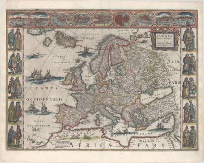
Auction 149, Lot 412
Subject: Europe
Blaeu, Willem
Europa Recens Descripta, 1643
Size: 22.1 x 16.3 inches (56.1 x 41.4 cm)
Estimate: $3,250 - $4,000
Blaeu's Carte-a-Figures Map of Europe
Sold for: $2,750
Closed on 5/21/2014
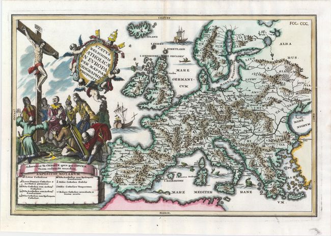
Auction 149, Lot 413
Subject: Europe
Scherer, Heinrich
Status Religionis Catholicae in Europa per Mappam Geographicam Proposit., 1702
Size: 13.8 x 9.1 inches (35.1 x 23.1 cm)
Estimate: $600 - $750
Rare Map Showing the Spread of Catholicism Through Europe
Sold for: $600
Closed on 5/21/2014
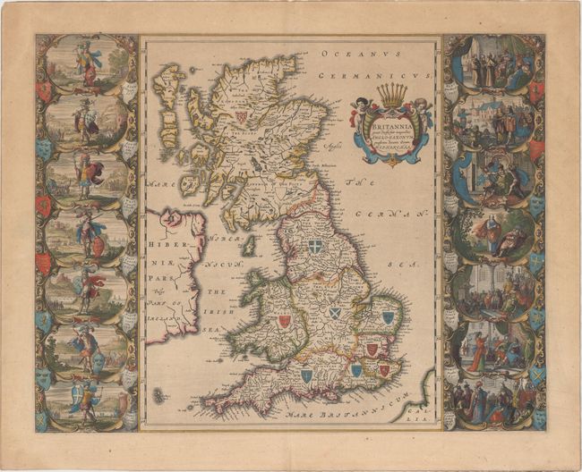
Auction 149, Lot 420
Subject: Britain
Blaeu, Johannes
Britannia Prout Divisa fuit Temporibus Anglo-Saxonum, Praesertim Durante Illorum Heptarchia, 1645
Size: 20.3 x 16.3 inches (51.6 x 41.4 cm)
Estimate: $3,000 - $4,000
Decorative Map of Britain with Vignettes of Saxon History
Sold for: $2,200
Closed on 5/21/2014
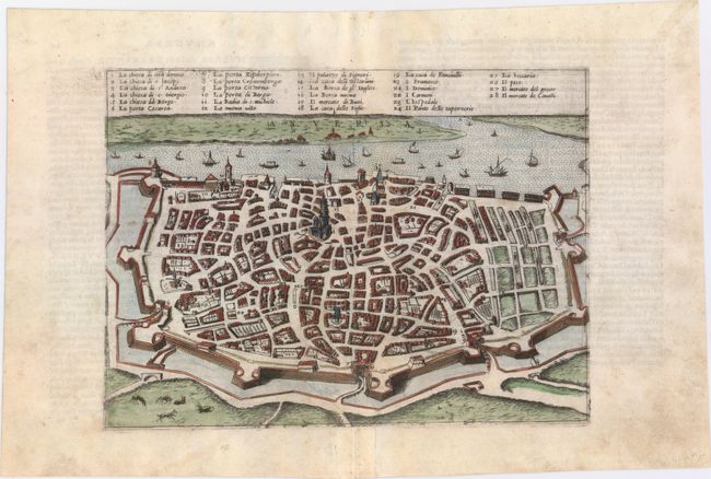
Auction 149, Lot 484
Subject: Antwerp, Belgium
Forlani, Paolo de
Anversa, 1569
Size: 10.8 x 7.9 inches (27.4 x 20.1 cm)
Estimate: $950 - $1,200
Forlani's Rare View of Antwerp
Unsold
Closed on 5/21/2014
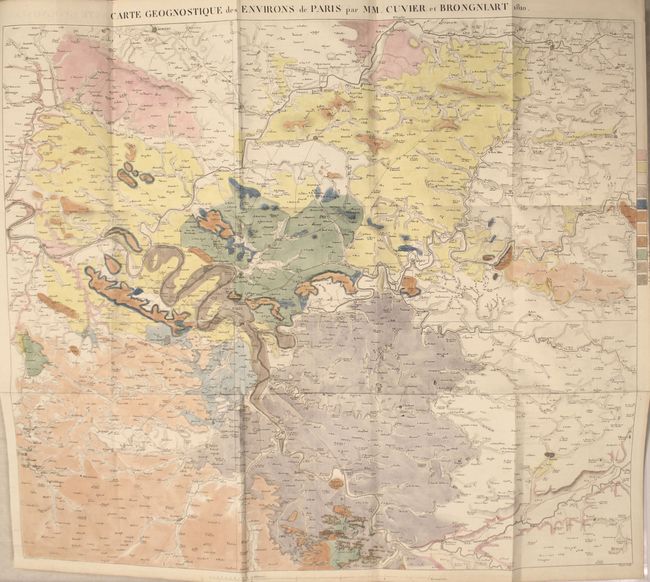
Auction 149, Lot 495
Subject: Paris, France
Memoires de la Classe des Sciences Mathematiques et Physiques de l'Institut Imperial de France, 1811
Size: 8.1 x 10.3 inches (20.6 x 26.2 cm)
Estimate: $1,500 - $1,800
First Modern Geological Map of Paris, France
Unsold
Closed on 5/21/2014
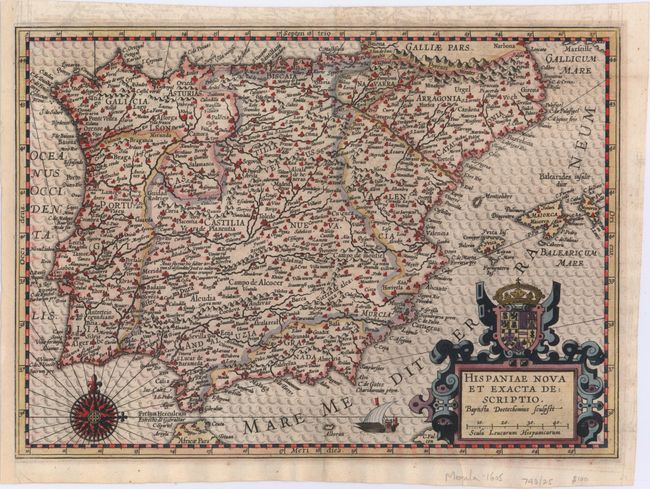
Auction 149, Lot 497
Subject: Spain & Portugal
Merula, Paulus G.
Hispaniae Nova et Exacta Descriptio, 1605
Size: 12.8 x 9.2 inches (32.5 x 23.4 cm)
Estimate: $1,000 - $1,300
Rare Map of the Iberian Peninsula
Sold for: $500
Closed on 5/21/2014

Auction 149, Lot 565
Subject: Rome, Italy
Piranesi, Giovanni Battista
Veduta dell' Anfiteatro Flavio detto il Colosseo, 1850
Size: 27.9 x 19.3 inches (70.9 x 49 cm)
Estimate: $2,000 - $2,400
Piranesi's Famous Bird's-Eye View of the Coliseum
Unsold
Closed on 5/21/2014
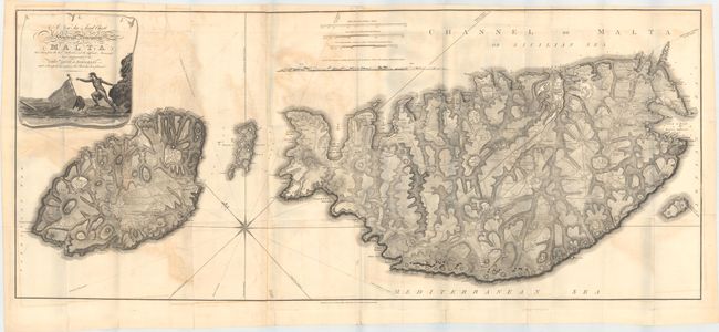
Auction 149, Lot 570
Subject: Malta
Neele, Samuel John
A New Sea & Land Chart of the Sovereign Principality of Malta; Laid Down from the Best Authorities and the Different Manuscript Maps Communicated to the Chevr. Louis de Boisgelin..., 1804
Size: 50.8 x 21.6 inches (129 x 54.9 cm)
Estimate: $2,500 - $3,500
Rare, Large Format Map of Malta
Sold for: $1,800
Closed on 5/21/2014
8 lots