Subject: Utopia
Period: 1710 (circa)
Publication:
Color: Hand Color
Size:
22.5 x 19.1 inches
57.2 x 48.5 cm
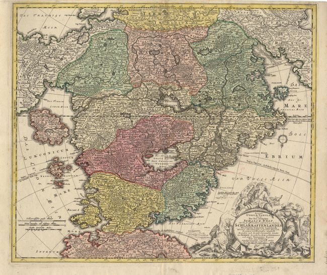
Schlarraffenlandes is the German Fool's Paradise, an imaginary country of idleness and luxury. It is based on the 16th century satire of Hans Sachs, where chickens, geese, and pigeons fly around already cooked and every house is surrounded by a hedge of sausage. Homann's map expands this theme considerably by providing a geographic framework for the imaginary land of vice and debauchery. Schlarraffenlandes is divided into 19 regions with such names as Prodigalia Regnum (Kingdom of Extravagance), Magni Stomachi Imperium (Empire of Fat Stomachs), Pigritaria (Land of Indolence) and Lurconia (Land of Gluttony) all surrounding a central Venerea Meer (Sea of Lust). The map is literally covered in amusing names for places, rivers and geographical features. There is the Loafing Department, Braggadocio Center, Fool's Home, Blasphemy City, Tobacco Island, Sea of Trollops, and the Sea of Drunkenness. The four kingdoms surrounding Utopia are Youth in the east and Old Age to the west. In the south is Tartari Regnu - the nether regions at the end of the earth or Hell where all inhabitants of Schlarraffenlandes are destined to go. In the north is the Terra Sancta Incognita (Unknown Land of Religion) where Jerusalem is shown shining from a mountaintop. The large title cartouche at bottom is surrounded by figures demonstrating all aspects of human debauchery and foolishness.
References: Hill: Cartographical Curiosities #70 pp.57-58; Tooley (MCC) Geographical Oddities #87.
Condition: A
Full original color with uncolored cartouche, with faint offsetting of a little color.