Subject: Northern Pacific
Period: 1777 (published)
Publication: Diderot's Encyclopedea
Color: Black & White
Size:
15 x 11.8 inches
38.1 x 30 cm
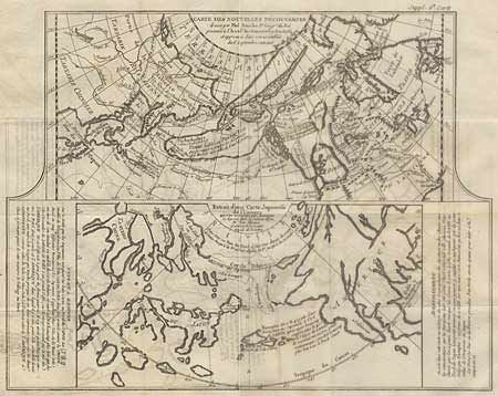
Two maps within a single border. Each covers the north Pacific, including the continents bordering it. The top map depicts the theories of Philip Buache concerning the NORTHWEST PASSAGE, with numerous possible routes through North America, including "Lace de Valasco, Lac de Fonte and Mer de l'Ouest" Alaska is shown as an elongated island. In Asia Kamtchatka is fairly well formed, but Japan is still quite misshapen. The bottom chart depicts the region per Kaempfer, with Japan nicely detailed, but the coasts of both Asia and North America very deformed. A interesting chart in fine condition. Ref: Wagner (NW) I, pp 158-162, Pedley #452. Faint ink offsetting which can easily be erased, else very fine crisp impression.
References:
Condition: A+