Subject: Central United States
Period: 1860 (circa)
Publication: American State Papers, Military Affairs, Vol. 7
Color:
Size:
15 x 21 inches
38.1 x 53.3 cm
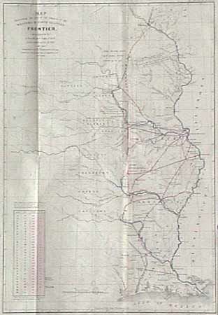
These maps were issued as part of the continuing debate over the nature of the Frontier Defenses between the Mississippi River and the Rocky mountains. One is as proposed by J.R. Poinsett, Secretary of War, in his report of Dec. 30, 1837. The other is Charles Gratiot's proposal of Oct. 31, 1837. Both maps depict the same region and the Indian nations west of the states of MO, AR and LA. Notations concerning the regions ceded by several Indian nations with the dates of the treaties. The maps are a fascinating comparison of the region, locating many military forts and outposts from Ft. Jessup, to Ft. Snelling. Gratiot's map includes a table with distance between forts marked both in miles and "a day's march". The defense network is linked with red lines and the major waterways are colored in blue. Poinsett's map is uncolored.
References:
Condition: A+