Subject: Colonial United States
Period: 1703 (published)
Publication: Nouveaux Voyages de M. le Baron de Lahontan dans l'Amerique Septentrionale
Color: Black & White
Size:
26.25 x 11 inches
66.7 x 27.9 cm
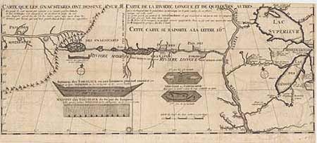
One of the most influential, and fanciful, maps in American cartographic history. It purports to show the "Riviere Longue" flowing from the mountains in the west (Rocky Mts), home to the "Gnacsitares" Indians, and connecting to the Mississippi River. On the western side of the mountains is another river, presumably flowing into the Pacific. Lahontan''s concept was copied by virtually all 18th century cartographers including Moll, Senex, Popple, and De l''Isle, thus perpetuating the myth. The map also includes balloon-shaped Lakes Superior and Michigan. This is the first state without pagination at top. Ref: Schwartz and Ehrenberg #81; Kershaw #298; Verner & Stuart Stubbs #20. Very minor offsetting, still fine. Added to description on 6/7/00 - Top right margin trimmed to 1/8" of engraving.
References:
Condition: A+