Subject: Canada and Alaska
Period: 1825-27 (published)
Publication: Atlas Universel…
Color: Hand Color
Size:
22.8 x 19 inches
57.9 x 48.3 cm
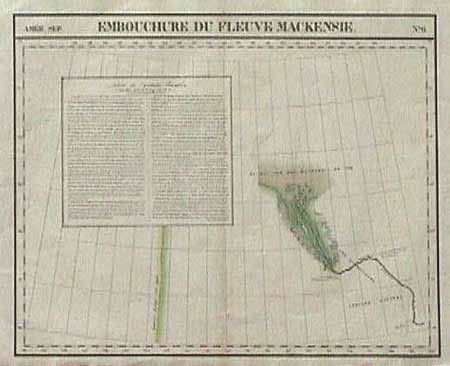
A fine map from this uncommon and very interesting atlas. There was only one edition of this monumental work. Each sheet covers an area of approximately 20 deg. of longitude (from Paris) and 6 deg. of latitude. This was the first atlas in which all maps were made on the same scale(1: 1,641,836). This sheet shows Alexander MacKenzie's track (1789) up the river to the Beaufort Sea. Both this river and the bay were named in his honor. Also shown is the border between Canada and Alaska, as agreed between Britain and Russia in 1823. Inset into the map is a letter (in French text) from Capt. Franklin dated 7 Sept. 1825. Ref: Phillips' Atlases #747. Minor toning on bottom fold and a small tear in margin.
References:
Condition: A