Subject: Pacific
Period: 1595 (published)
Publication: Theatrum Orbis Terrarum
Color: Hand Color
Size:
19.5 x 13.5 inches
49.5 x 34.3 cm
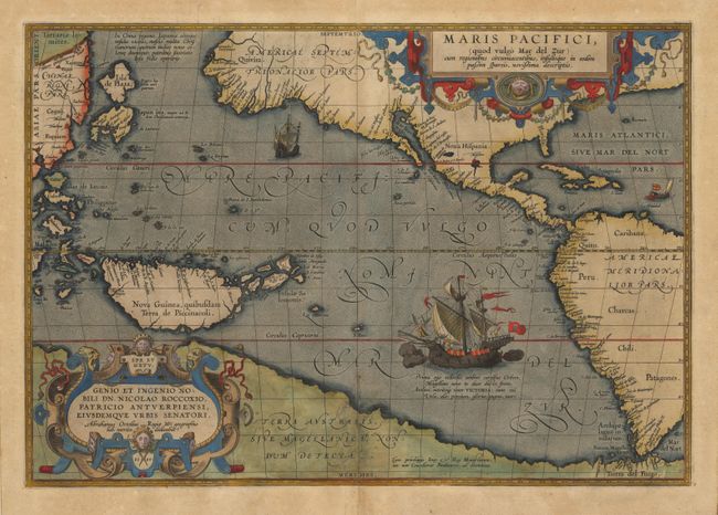
Unquestionably one of the most important maps originated by Abraham Ortelius. This fine example, in beautiful original color, is from a Latin edition printed at the celebrated press of Christophe Plantin. Ortelius' seminal map of the Pacific is the first printed map devoted to the Pacific and the first to label the Americas separately as North and South subsequent to Mercator's 1538 world map. The map draws on the cartography of Frans Hogenberg, Mercator's world map of 1569, and Portuguese manuscript maps of Bartolomeo de Lasso. It widens the gap between Asia and North America while properly locating Japan and the Philippines. North America is depicted considerably narrower and more correctly at the Tropic of Cancer and the head of the Gulf of California is shown in a new form with the "R. Grande" being introduced for the first time. The large southern continent "Terra Australis" stretches over the bottom of the map, but the name Tierra del Fuego appears south of the Strait of Magellan. Two elaborate cartouches; the one at top obscuring most of eastern North America, and the lower cartouche containing the date 1589. Magellan's surviving ship "Victoria" is pictured with two smaller ships. Superb color, including the historiated first letter on verso.
References: Goss (NA) #14, Burden #74, Wheat (TMW) #24, Phillips (A) #400, van den Broecke #12.
Condition: A+
Expert repair of bottom centerfold, light soil in margins, overall a fine example of this important map.