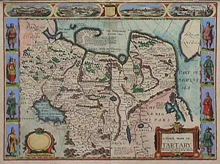
Subject: Northern Asia
Period: 1626 (dated)
Publication:
Color: Hand Color
Size:
20 x 15.5 inches
50.8 x 39.4 cm
Carte de figures map of Russia in Asia, Mongolia, an insular Korea, and parts of China. Also depicts Alaska across "The Strait of Anian". The map is fully engraved with mountains and forests, the Great Wall of China, numerous towns and fascinating notations. Included in the four views at top is a view of Nova Zembla, the winter quarters of Barents, the Dutch explorer who searched for a northern passage between Russia and America. In the side panels are figures of the people in their native costume. Imprint of George Humble. Close top margin, as issued and minor printer's crease along bottom fold.
References:
Condition: A