Subject: Ukraine, Russia & Black Sea
Period: 1715 (circa)
Publication:
Color: Hand Color
Size:
19.1 x 22.9 inches
48.5 x 58.2 cm
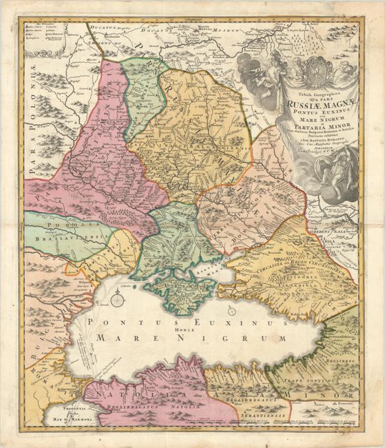
This superb map of the region bordering the Black Sea depicts present-day Ukraine and extends to include Constantinople in the south and north to Moscow and Smolensko. Great detail throughout shows mountains, watershed, roads, villages, towns, and battlefields. Within the Black Sea is an interesting notation and depiction of the Fluenta Danubii showing the waters of the Danube and the Dnieper Rivers flowing through the sea, into the Bosphorus, and out into the Mediterranean. The large decorative title cartouche is enveloped in clouds with several putti and the Russian coat of arms. The map is an updated, reissue of a map made by Major General George Mengden and Earl Yakov Bruce based on Russian Army routes during the Azov campaign of Peter I in 1695-96. The plate went through several revisions with this version removing the portrait and dedication to Peter I and adding the newly built Volga-Don canal (Canalis Perevoloc) just below the cartouche. This is the second state, with Homann's privilege added to the title cartouche.
References: Vavrychyn, Dashkevych & Kryshtalovych, Vol. II, p.132-33.
Condition: B
Full contemporary color on a bright sheet with a coat of arms watermark, light soiling, and a bit of toning along the centerfold at right. Chips in the right-hand corners of the sheet have been professionally repaired, with approximately a 1" square section of the map replaced in facsimile at bottom right.