Subject: Loire River & Orléans Canal
Period: 1705 (circa)
Publication:
Color: Hand Color
Size:
25.6 x 15 inches
65 x 38.1 cm
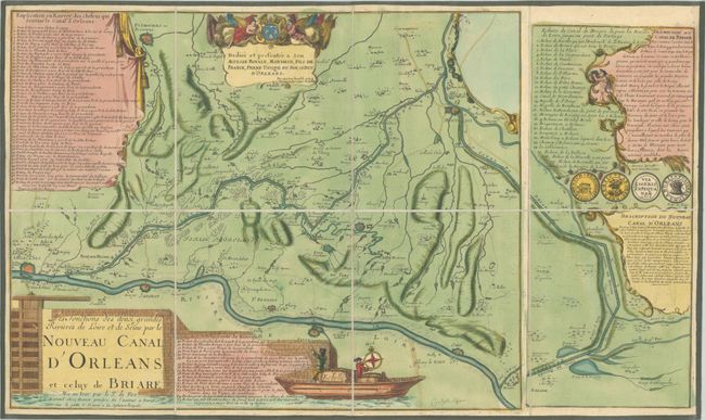
The focus of this map is on the newly completed Orléans Canal, which connected the Loire River to the Seine River through the Loing Canal. A cartouche at far right explains how the Orléans Canal came to be. In 1679, the King of France granted the Duke of Orleans the right to build the canal, and lent the Duke money to do so. After the canal was completed in 1692, tolls were collected from merchants who used the canal in order to repay the king. The canal was used primarily to transport timber from the Orleans region to Paris. The Canal Briare, also constructed in the 17th century, is also depicted and another inset explains its history. Numbered keys are included to list the various locks and bridges along each of the canals. The map follows the Loire River from Orleans to Gien, with the canals connecting near Montargis. The map was printed from two separate plates on one sheet, and is dedicated to the Duke of Orleans. The lovely title cartouche depicts a boat passing through one of the locks on the canal. Engraved by C. Inselin.
References:
Condition: B+
Full contemporary color, dissected and mounted on linen with green ribbon edging. There is light soiling.