Subject: Port Arthur, Texas
Period: 1897 (dated)
Publication:
Color: Printed Color
Size:
65.9 x 28.1 inches
167.4 x 71.4 cm
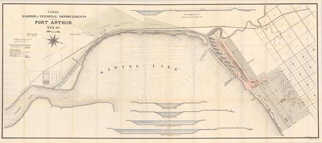
This very large and early map of Port Arthur was issued only 2 years after the founding of the city. It was named after Arthur E. Stilwell, founder of the Kansas City, Pittsburg & Gulf Railroad, and was established in order to connect Kansas City to the Gulf of Mexico. The map features a detailed street plan along the northern edge of Sabine Lake along with the company's railroad yard in red and dock company property in green. Includes 5 cross-sections and a compass rose indicating North is oriented to the right. Port Arthur would flourish after the Spindletop oil discovery in 1901, and by 1909 the city had become the 12th largest port in the U.S. By 1913, Port Arthur was the second largest oil refiner. Drafted by Robert Gillham and lithographed by Norris Peters in Washington.
References:
Condition: B+
Issued folding on a bright sheet with faint offsetting. There are a number of short fold separations along the lower horizontal fold that have been partially repaired on verso with archival tape.