Subject: Colonial New England & Mid-Atlantic United States
Period: 1700 (circa)
Publication: A New Sett of Maps both of Antient and Present Geography
Color: Hand Color
Size:
18.6 x 13.9 inches
47.2 x 35.3 cm
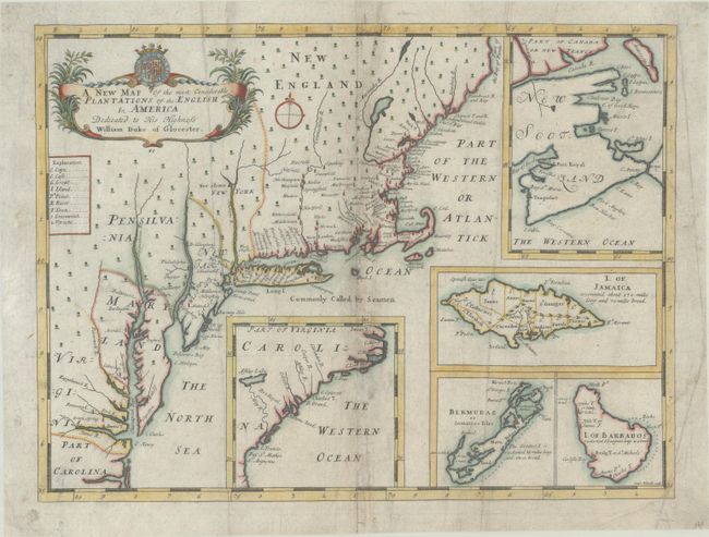
This decorative map of the English plantations in North America covers the area along the Atlantic coast from North Carolina north through New England. The map presents only limited detail with major towns located, mostly along the coast and concentrated in New England and New York. New Albanie stands out on the Hudson River, Baltimore is shown on a simplified Delaware peninsula, and Green Spring appears near Jamestown. This was the plantation of Sir William Berkeley, Governor of Virginia. The Atlantic is filled with inset plans of other British colonies. The map of New Scotland shows the hotly contested territory with its key Port Royal. The map of South Carolina shows the spurious Ashley Lake and May River, which are from John Lederer's important map of the colony. Further insets show the three key British islands of Jamaica, Barbados, and Bermuda. According to Shirley, Wells groused about the quality of his engravers in the introduction to A New Sett of Maps..., but this map, engraved by Sutton Nicholls, has a most charming style. It is embellished with a decorative title cartouche that includes the dedication to William, Duke of Gloucester, who was Wells's pupil at Oxford. The 11-year-old Duke, heir to the throne, died a few months after the atlas was published. Wells's maps were published over time by subscription and then assembled into his A New Sett of Maps, which was published between 1700 and circa 1743. The atlas was specifically designed to educate young university students on geography. This is the rare first state of the plate without any pagination.
References: Burden #773; Cumming (SE) #130; Manasek #68; McCorkle #700.9; Shirley T.WELL-1a #41.
Condition: B
A dark impression with some short separations and a few small holes along the centerfold that have been archivally repaired on verso. There are a few vertical creases that run the length of the map and some soiling.