Subject: Western Hemisphere - America
Period: 1664 (dated)
Publication: Cartes de Geographie les Plus Nouvelles et les Plus Fideles
Color: Hand Color
Size:
15.1 x 14.4 inches
38.4 x 36.6 cm
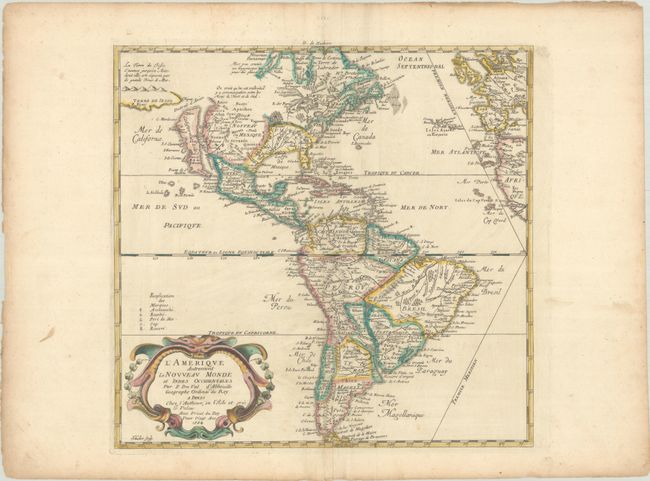
This uncommon map of the Americas is based largely on the cartography of Nicolas Sanson, Duval's uncle. In North America, the Great Lakes are shown open-ended in the west and California is depicted as an island. Above California is the Destroit d' Anien and the large Terre de Iesso, or land of Jesso, that was the result of confusing reports by De Vries on his expedition in the waters north of Japan. Several colonial settlements appear on the eastern seaboard including Iamestoun, Christina, London al: Boston, N. Amsterdam al: Manhate. In South America, the mythical Parime Lake is located in Guiana with its legendary Manoa-el dorado (City of Gold). There is good detail of the missions. The map includes the western coasts of Europe and Africa and the Prime Meridian goes through the Isle de Fer. The map was originally engraved in 1655 and appeared in several states until 1687, four years after Duval's death. Engraved by Jan L'Huilier.
See also lot 719 for Philip Burden's The Mapping of North America - A List of Printed Maps 1511-1670 that describes this map.
References: Burden #311 (State 4); McLaughlin #15 (State 2); Pastoureau, DUVAL II C #15.
Condition: B+
A crisp impression with contemporary color in the map and later color in the cartouche, on a bright sheet with a bunch of grapes watermark. There are extraneous creases along the centerfold, a few minute worm holes only visible when held to light, and light soiling that is mostly confined to the edges of the sheet.