Subject: Gibraltar
Period: 1785 (circa)
Publication:
Color: Hand Color
Size:
25.8 x 18 inches
65.5 x 45.7 cm
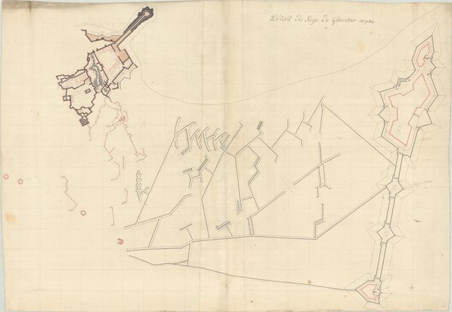
This is a detailed manuscript plan of the fortifications during the Great Siege of Gibraltar (1779-83). The drawing is oriented with north approximately to the right and shows the Old Mole and the British fortifications of Gibraltar at left. At far right are Fort St. Philip, Fort St. Barbara and the Spanish lines.
The Great Siege of Gibraltar was the largest and longest action fought during the American War of Independence. Through much of the 18th century, Gibraltar served as a strategic port for controlling trade in the Mediterranean. At the end of the War of Spanish Succession, Britain gained control of Gibraltar in the Treaty of Utrecht in 1713. Spain sought to recapture the peninsula, however repeated negotiations between Britain and Spain failed. In 1779, Spain signed a treaty with France to combine forces in recovering lost territories from Britain. After the outbreak of the American War of Independence, Spain declared war on Britain and sought help from its French ally to recapture Gibraltar. The height of the siege occurred on September 13, 1782, known as the Grand Assault. The Spanish and French had formed a fleet of 10 battering ships just off the coast of Gibraltar, assisted by numerous Spanish gunboats and bomb-vessels, as well as an army of 35,000 Spanish and French troops on land. On September 13, they opened fire on the British from both land and sea, but were readily defeated by the British with their "red-hot shot." The Spanish failed to regain Gibraltar, with the siege finally ending on February 7, 1783.
References:
Condition: B+
Drawn on two sheets of hand-laid paper that have been glued together and folded. The paper has the watermarks of a Strasbourg lily and a Maltese cross over a "P". There is a small hole in the center of the plan, light soiling in the image, and heavy soiling along the edge of the sheet at top left.