Subject: Washington, D.C.
Period: 1887 (dated)
Publication:
Color: Black & White
Size:
26 x 19.9 inches
66 x 50.5 cm
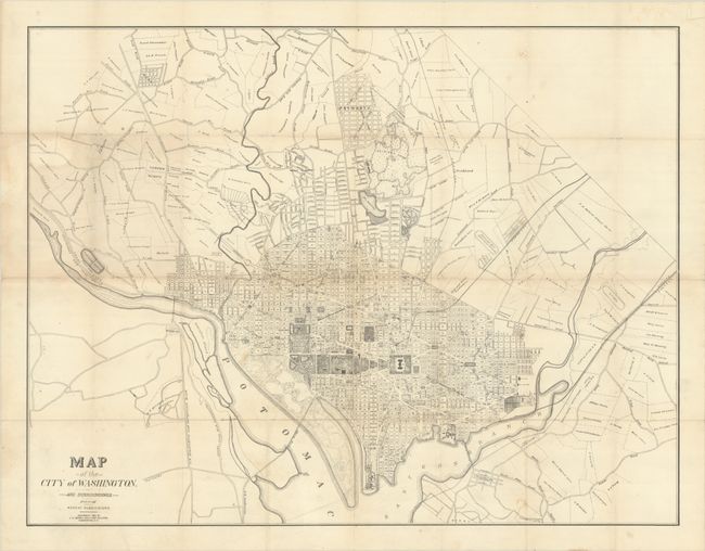
This scarce and richly detailed cadastral map of Washington, D.C. by A.G. Gedney captures the city on the cusp of dramatic transformation. In 1888, just one year after this map was published, the city began operating its first motorized streetcars, leading to greater expansion of the city's boundaries. The map shows some of the new development in embryonic form. It spans from Brightwood south to Barry (now known as Barry Farm), a notable Black enclave established by the Freedmen's Bureau after the Civil War, and from Georgetown east to Northeast Washington, which is divided into the tracts of various landowners. Several new developments and neighborhoods are identified, including Uniontown, the first officially planned suburb of D.C., now known as Anacostia; Petworth, which was officially registered as a development after the map's publication, in 1889; Rosslyn; and the now-defunct Reno. The grid of the city proper is well delineated and locates notable sites such as the Capitol, the President's House, the Washington Monument, the Smithsonian, Dupont Circle, the U.S. Navy Yard, and several parks. Arlington National Cemetery is depicted west of the Potomac, and the vast campus of Soldier's Home appears to the southeast of Petworth.
References: Phillips (DC) [PW 317].
Condition: B+
Issued folding, now flat, with archival repairs to numerous small fold separations on verso. There is light soiling, minor uneven toning, and two 0.5" holes that have been infilled with archival materials.