Subject: Central United States
Period: 1856 (dated)
Publication: A New Universal Atlas
Color: Hand Color
Size:
12.9 x 15.8 inches
32.8 x 40.1 cm
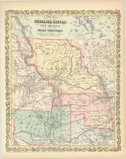
When Desilver took over the publication of Mitchell's atlas in late 1855, he realized that the atlas was missing a map showing the new territories of Kansas and Nebraska. There was considerable public interest in these territories that had been created by the Kansas-Nebraska Act of 1854 due to the politics involved. The act repealed the Missouri Compromise of 1820, and allowed settlers in those territories to determine if they would allow slavery within their boundaries. Nebraska Territory stretches between Kansas and the border with Canada, and from the continental divide to the early Minnesota Territory at the Missouri River. Kansas stretches west to include South Park in present-day Colorado. New Mexico Territory is shown in its largest configuration, including present-day Arizona and much of southern Colorado. Oklahoma has its correct boundaries but is Indian Territory. Interesting features and notations include several emigrant and exploration routes in the region, the Great Indian Treaty Ground in Nebraska, and an Uninhabited Region in Arizona. The Road from Ft. Smith to Santa Fe 900 miles made by order of Gen. Arbuckle" and another Road from Ft. Smith to Dona Ana 820 miles made by order of Gen. Arbuckle refer to routes to the gold mines in California. This map was published circa 1857 with a more pronounced bulge in the western boundary of Nebraska Territory. Enclosed with a scroll border.
References:
Condition: A
A crisp impression with minor toning along the sheet edges and a short repaired edge tear confined to the bottom blank margin.