Subject: Southern United States
Period: 1792 (dated)
Publication:
Color: Hand Color
Size:
14.3 x 12.4 inches
36.3 x 31.5 cm
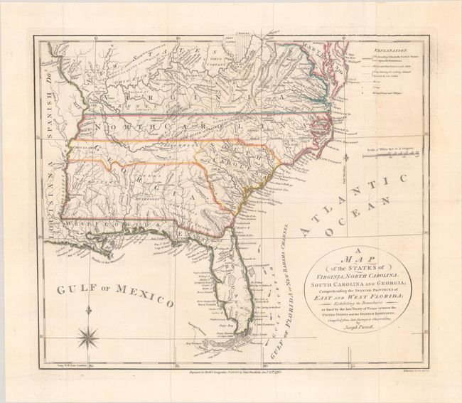
This fine map is a fascinating historical document of the United States following the Revolutionary War. It includes an early reference to the New State of Franklin in western North Carolina. The map includes a great amount of information including boundaries claimed by the various Indian Nations and trading paths on the western frontier. It shows early settlements, including a Moravian Settlement in North Carolina, and the Cumberland Settlements in present-day Tennessee. At the top of the map, in the nascent Northwest Territory, the 7 Ranges denote the first application of the Public Land Survey System. Several bounty land grants are shown including the Ohio Company, Wabash Company, New Jersey Company, Illinois Company, and the Donation Lands of the Commonwealth of Virginia. A triangular shaped plot of land in the region of present-day West Virginia is labeled Indiana. In 1785, settlers in present-day western North Carolina and eastern Tennessee organized a state government to be named in honor of Benjamin Franklin, Franklin or Frankland. Congress turned down their appeal but the state maintained a legislature and governor until 1788. This ephemeral state appeared on a small number of maps into the early part of the 19th century.
References: McCorkle (18th C. Geography Books) #300-1; Dotson & Baker (OWA) #6.1; Baynton-Williams (TMC-72) p. 16, #4.
Condition: B+
Issued folding and now flat on a clean bright sheet with a hint of offsetting. There are archival repairs to a 2" edge tear at right and a couple of short fold separations in the blank margins.